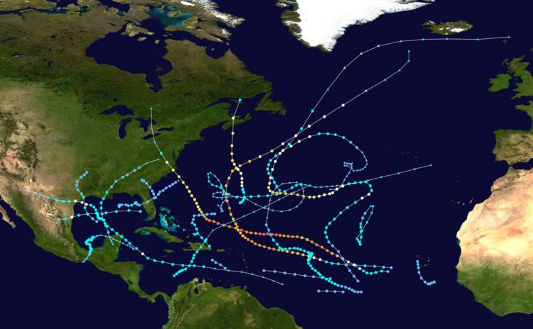
The 2003 Atlantic hurricane season was an active Atlantic hurricane season with tropical activity before and after the official bounds of the season – the first such occurrence in 50 years. The season officially began on June 1, 2003 and ended on November 30. However, a pre-season storm, Tropical Storm Ana, led to the season starting on April 20, and storm activity continued through December 11. The timeline includes information which was not operationally released, meaning that information from post-storm reviews by the National Hurricane Center, such as information on a storm that was not operationally warned upon, has been included. This timeline documents tropical cyclone formations, strengthening, weakening, landfalls, extratropical transitions, as well as dissipations during the season.
This season had 21 tropical depressions, 16 named storms, 7 hurricanes, and 3 major hurricanes, i.e. those that rank as Category 3 or higher on the Saffir-Simpson Hurricane Scale. Hurricane Fabian, Hurricane Isabel, and Hurricane Juan had their names retired due to the impact caused in Bermuda, the eastern United States, and Nova Scotia respectively. Both Fabian and Juan were the worst hurricanes to hit their respective areas, causing $450 million in damages and 16 fatalities. Hurricane Isabel was the strongest, deadliest, and costliest storm of the season. Isabel peaked as a Category 5 hurricane over the open waters of the Atlantic; however, it weakened to a Category 2 before impacting the east coast of the United States, causing $3.6 billion in damages and 51 fatalities.
April 202 a.m. EDT (0600 UTC) – Subtropical Storm Ana develops out of an
extratropical low 250 miles (400 km) west of
Bermuda.8 p.m. EDT (0000 UTC April 21) – Subtropical Storm Ana gains tropical characteristics and becomes Tropical Storm Ana.
April 242 a.m. EDT (0600 UTC) – Tropical Storm Ana loses tropical characteristics and becomes extratropical.
June 1The Atlantic hurricane season officially begins.
June 108 p.m. AST (0000 June 11) – Tropical Depression Two forms 1,145 mi (1,840 km) southwest of Brava, Cape Verde.June 118 p.m. AST (0000 June 12) – Tropical Depression Two dissipates over open waters.June 291 a.m. CDT (0600 UTC) A Tropical Depression forms 210 mi west-northwest of Cancun, Mexico.7 a.m. CDT (1200 UTC) – The Tropical Depression strengthens into Tropical Storm Bill.June 302 p.m. CDT (1900 UTC) – Tropical Storm Bill makes landfall near Cocodrie, Louisiana with winds of 60 mph (95 km/h).July 11 a.m. CDT (0600 UTC) – Tropical Storm Bill is downgraded to a tropical depression.July27 p.m. CDT (1800 UTC) – Tropical Depression Bill loses tropical characteristics and becomes extratropical.July 88 p.m. AST (1800 UTC) – Tropical Storm Claudette develops out of a tropical wave located 150 mi (240 km) north of Aruba.July 108 a.m. EDT (1200 UTC) – Tropical Storm Claudette intensifies into a hurricane in the western Caribbean Sea.2 p.m. EDT (1800 UTC) – Hurricane Claudette weakens back to a tropical storm.July 115 a.m. CDT (1000 UTC) – Tropical Storm Claudette makes landfall near Puerto Morelos, Mexico with winds of 60 mph (95 km/h).July 151 a.m. CDT (0600 UTC) – Tropical Storm Claudette re-intensifies into a hurricane in the northwestern Gulf of Mexico.10:30 a.m. CDT (1530 UTC) – Hurricane Claudette makes landfall near Matagorda Island, Texas with winds of 90 mph (145 km/h).7 p.m. CDT (0000 UTC July 16 UTC) – Hurricane Claudette weakens to a tropical storm.July 168 a.m. AST (1200 UTC) – Tropical Depression Four forms 635 mi (1,020 km) east of Bermuda.7 p.m. CDT (0000 UTC July 17 UTC) – Tropical Storm Claudette weakens to a tropical depression.8 p.m. AST (0000 UTC July 17 UTC) – Tropical Depression Four strengthens into Tropical Storm Danny.July 171 a.m. CDT (0600 UTC) – Tropical Depression Claudette degenerates into a remnant low-pressure area.July 182 p.m. AST (1800 UTC) – Tropical Storm Danny strengthens into a hurricane.July 192 p.m. AST (1800 UTC) – Hurricane Danny weakens to a tropical storm.2 p.m. AST (1800 UTC) – Tropical Depression Six forms 1035 mi (1675 km) east of the Lesser Antilles.July 202 p.m. AST (1800 UTC) – Tropical Storm Danny weakens to a tropical depression.July 212 a.m. AST (0600 UTC) – Tropical Depression Danny degenerates into a remnant low-pressure area.2 p.m. AST (1800 UTC) – Tropical Depression Six dissipates over open waters.July 258 p.m. EDT (1200 UTC) – Tropical Depression Seven forms 60 mi (95 km) east of Daytona Beach, Florida.July 262 a.m. EDT (0600 UTC) – Tropical Depression Seven makes landfall near St. Catherines Island, Georgia with winds of 30 mph (45 km/h).July 272 a.m. EDT (0600 UTC) – Tropical Depression Seven dissipates inland.August 148 p.m. EDT (1800 UTC) – Tropical Storm Erika develops out of an area of low pressure about 85 mi (140 km) west-southwest of Fort Myers, Florida.August 165:30 a.m. CDT (1030 UTC) – Tropical Storm Erika strengthens into a hurricane and makes landfall near Boca San Rafael, Mexico in northeastern Tamaulipas with winds of 75 mph (120 km/h)1 p.m. CDT (1800 UTC) – Hurricane Erika weakens to a tropical storm.7 p.m. CDT (0000 UTC August 17) – Tropical Storm Erika weakens to a tropical depression.August 171 a.m. CDT (0600 UTC) – Tropical Depression Erika dissipates over the mountains of northern Mexico.August 218 a.m. AST (1200 UTC) – Tropical Depression Nine forms about 260 mi (415 km) south of San Juan, Puerto Rico.August 222 p.m. AST (1800 UTC) – Tropical Depression Nine dissipates over open waters.August 272 p.m. AST (1800 UTC) – Tropical Depression Ten forms 420 mi (675 km) west of the Cape Verde Islands.August 288 a.m. AST (1200 UTC) – Tropical Depression Ten strengthens into Tropical Storm Fabian.August 298 p.m. AST (0000 UTC August 30) – Tropical Storm Fabian intensifies into a hurricane.August 308 a.m. AST (1200 UTC) –Hurricane Fabian strengthens into a Category 2 hurricane.7 a.m. PDT (1200 UTC) – Tropical Depression Eleven forms 335 mi (540 km) east-southeast of Corpus Christi, Texas.2 p.m. AST (1800 UTC) – Hurricane Fabian strengthens into a major hurricane—a storm with winds of 111 mph (178 km/h) or higher.1 p.m. PDT (1800 UTC) – Tropical Depression Eleven strengthens into Tropical Storm Grace.August 316 a.m. PDT (1100 UTC) – Tropical Storm Grace makes landfall near Galveston Island, Texas with winds of 40 mph (65 km/h).2 p.m. AST (1800 UTC) – Hurricane Fabian strengthens into a Category 4 hurricane.1 p.m. PDT (1800 UTC) – Tropical Storm Grace weakens to a tropical depression.September 12 p.m. AST (1800 UTC) – Hurricane Fabian reaches its peak intensity with winds of 145 mph (230 km/h) while located 310 mi (500 km) northeast of Barbuda.September 27 a.m. CDT (1200 UTC) – Tropical Depression Grace dissipates as it gets absorbed by a frontal system.September 32 a.m. AST (0600 UTC) – Hurricane Fabian weakens to a Category 3 hurricane.2 p.m. EDT (1800 UTC) – Tropical Depression Twelve forms 300 mi (480 km) west of Tampa, Florida.8 p.m. AST (0000 UTC September 4) – Hurricane Fabian re-intensifies into a Category 4 hurricane.September 42 a.m. AST (0600 UTC) – Hurricane Fabian weakens to a Category 3 hurricane again.8 p.m. AST (0000 UTC September 5) – Hurricane Fabian re-intensifies into a Category 4 hurricane.September 52 a.m. AST (0600 UTC) – Hurricane Fabian weakens to a Category 3 hurricane once more.2 a.m. EDT (0600 UTC) – Tropical Depression Twelve strengthens into Tropical Storm Henri.4 p.m. AST (2000 UTC) – Hurricane Fabian makes its closest approach to land, passing 14 mi (23 km) to the west of Bermuda with winds of 115 mph (180 km/h).8 p.m. EDT (0000 UTC September 6) – Tropical Storm Henri weakens to a tropical depression.8 p.m. AST (0000 UTC September 6) – Tropical Depression Thirteen forms 470 mi (755 km) west-southwest of Brava, Cape Verde.September 62 a.m. AST (0600 UTC) – Tropical Depression Thirteen strengthens into Tropical Storm Isabel.5 a.m. EDT (0900 UTC) – Tropical Depression Henri makes landfall near Clearwater, Florida with winds of 35 mph (55 km/h).8 p.m. AST (0000 UTC September 7) – Hurricane Fabian weakens into a Category 2 hurricane.September 78 a.m. AST (1200 UTC) – Hurricane Fabian weakens to a Category 1 hurricane.8 a.m. AST (1200 UTC) – Tropical Storm Isabel strengthens into a hurricane.September 82 a.m. AST (0600 UTC) – Hurricane Isabel strengthens into a Category 2 hurricane.2 a.m. AST (0600 UTC) – Tropical Depression Fourteen forms 290 mi (465 km) southeast of the southernmost Cape Verde islands.8 a.m. AST (1200 UTC) – Hurricane Isabel strengthens into a major hurricane.2 p.m. AST (1800 UTC) – Hurricane Fabian loses tropical characteristics and becomes extratropical, while retaining hurricane-force winds, over the open waters of the north Atlantic Ocean.2 p.m. EDT (1800 UTC) – Tropical Depression Henri loses tropical characteristics and becomes extratropical shortly before dissipating.8 p.m. AST (0000 UTC September 9) – Hurricane Isabel strengthens into a Category 4 hurricane.September 98 p.m. AST (0000 UTC September 10) – Hurricane Isabel weakens to a Category 3 hurricane.September 108 a.m. AST (1200 UTC) – Hurricane Isabel re-intensifies into a Category 4 hurricane.2 p.m. AST (1800 UTC) – Tropical Depression Fourteen dissipates.September 112 p.m. AST (1800 UTC) – Hurricane Isabel strengthens into a Category 5 hurricane, becoming the strongest storm of the season; winds peak at 165 mph (270 km/h) and the minimum pressure is 915 mbar (hPa; (27.03 inHg). At this time, Isabel is located 560 mi (900 km) northeast of Guadeloupe.September 128 p.m. AST (0000 UTC September 13) – Hurricane Isabel weakens to a Category 4 hurricane.September 132 p.m. AST (1800 UTC) – Hurricane Isabel re-intensifies into a Category 5 hurricane.8 p.m. AST (0000 UTC September 14) – Hurricane Isabel weakens to a Category 4 hurricane again.September 142 p.m. AST (1800 UTC) – Hurricane Isabel re-intensifies into a Category 5 hurricane for the third and final time.8 p.m. AST (0000 UTC September 15) – Hurricane Isabel weakens to a Category 4 hurricane once more.September 158 p.m. EST (0000 UTC September 16) – Hurricane Isabel weakens to a Category 3 hurricane.September 168 a.m. (1200 UTC) – Hurricane Isabel weakens to a Category 2 hurricane.September 181 p.m. EST (1700 UTC) – Hurricane Isabel makes landfall near Drum Inlet, North Carolina with winds of 105 mph (165 km/h).8 p.m. EST (0000 UTC September 19) – Hurricane Isabel weakens to a Category 1 hurricane.September 192 a.m. EST (0600 UTC) – Hurricane Isabel weakens to a tropical storm.8 a.m. EST (1200 UTC) – Tropical Storm Isabel loses tropical characteristics and becomes extratropical.September 248 a.m. AST (1200 UTC) – Tropical Depression Fifteen forms 345 mi (555 km) southeast of Bermuda.8 p.m. AST (0000 UTC September 25) – Tropical Depression Fifteen strengthens into Tropical Storm Juan.September 252 p.m AST (1800 UTC) – Tropical Depression Sixteen forms 920 mi (1,480 km) west-southwest of the Cape Verde Islands.September 268 a.m. AST (1200 UTC) – Tropical Storm Juan strengthens into a hurricane.September 272 p.m. AST (1800 UTC) – Hurricane Juan strengthens into a Category 2 hurricane.2 p.m. AST (1800 UTC) – Tropical Depression Sixteen strengthens into Tropical Storm Kate.September 2811 p.m. AST (0300 UTC September 29) – Hurricane Juan makes landfall near Halifax, Nova Scotia with winds of 100 mph (160 km/h).September 292 a.m. AST (0600 UTC) – Hurricane Juan weakens to a Category 1 hurricane as it passes over Prince Edward Island with winds of 75 mph (120 km/h).8 a.m. AST (1200 UTC) – Hurricane Juan weakens to a tropical storm.2 p.m. AST (1800 UTC) – Tropical Storm Juan is absorbed by a large extratropical low.2 p.m. AST (1800 UTC) – Tropical Storm Kate strengthens into a hurricane.September 302 a.m. AST (0600 UTC) – Hurricane Kate weakens to a tropical storm.October 12 p.m. AST (1800 UTC) – Tropical Storm Kate re-intensifies into a hurricane.1 p.m. CDT (1800 UTC) – Tropical Storm Larry develops out of an extratropical gale while located 300 mi (483 km) east-southeast of Tampico, Mexico.October 32 a.m. AST (0600 UTC) – Hurricane Kate strengthens into a Category 2 hurricane.2 p.m. AST (1800 UTC) – Hurricane Kate strengthens into a major hurricane.October 42 p.m. AST (1800 UTC) – Hurricane Kate reaches its peak intensity with winds of 125 mph (205 km/h) with a minimum pressure of 952 mbar (hPa; 28.12 inHg) while located 645 mi (1,040 km) southeast of Bermuda.October 52 a.m. AST (0600 UTC) – Hurricane Kate weakens to a Category 2 hurricane.5 a.m. CDT (1000 UTC) – Tropical Storm Larry makes landfall near Paraíso in the Mexican state of Tabasco with winds of 60 mph (95 km/h).8 p.m. AST (0000 UTC October 6) – Hurricane Kate weakens to a Category 1 hurricane.October 61 a.m. CDT (0600 UTC) – Tropical Storm Larry weakens to a tropical depression.7 a.m. CDT (1200 UTC) – Tropical Depression Larry degenerates into a remnant low-pressure area.October 72 a.m. AST (0600 UTC) – Hurricane Kate weakens to a tropical storm.8 p.m. AST (0000 UTC October 8) – Tropical Storm Kate loses tropical characteristics and becomes extratropical over the northern Atlantic Ocean while located several hundred miles northeast of Newfoundland.October 102 p.m. AST (1800 UTC) – Tropical Storm Mindy forms 80 mi (130 km) northeast of Santo Domingo, Dominican Republic.October 122 a.m. AST (0600 UTC) – Tropical Storm Mindy weakens to a tropical depression.8 p.m. AST (0000 UTC October 13) – Tropical Depression Nineteen forms 1,030 mi (1,660 km) west-southwest of the Cape Verde islands.October 142 a.m. AST (0600 UTC) – Tropical Depression Mindy dissipates.2 p.m. AST (1800 UTC) – Tropical Depression Nineteen strengthens into Tropical Storm Nicholas.October 228 p.m. AST (0000 UTC October 23) – Tropical Storm Nicholas weakens to a tropical depression.October 238 p.m. AST (0000 UTC October 24) – Tropical Depression Nicholas degenerates into a broad area of low pressure while located 605 mi (975 km) northeast of Barbuda.November 30The Atlantic hurricane season officially ends.
December 48 a.m. AST (1200 UTC) – Tropical Depression Twenty forms about 345 mi (560 km) south of Kingston, Jamaica.2 p.m. AST (1800 UTC) – Tropical Depression Twenty strengthens into Tropical Storm Odette.December 67 p.m. AST (2300 UTC) – Tropical Storm Odette makes landfall near Cabo Falso, Dominican Republic with winds of 60 mph (95 km/h).December 72 p.m. AST (1800 UTC) – Tropical Storm Odette loses tropical characteristics and becomes extratropical.2 p.m. AST (1800 UTC) – Subtropical Storm Peter forms 835 mi (1,340 km) south-southwest of the Azores.December 92 a.m. AST (0600 UTC) – Subtropical Storm Peter acquires enough tropical characteristics to be classified a tropical storm.December 108 a.m. AST (1200 UTC) – Tropical Storm Peter weakens to a tropical depression.December 112 a.m. AST (0600 UTC) – Tropical Depression Peter loses tropical characteristics and becomes extratropical shortly before being absorbed by a frontal system.