
Population 93 (in 2001) Unitary authority Dialling code 01264 | OS grid reference SU3058 Sovereign state United Kingdom UK parliament constituency Devizes | |
 | ||
Tidcombe and Fosbury is a civil parish in Wiltshire, England, about 10 miles (16 km) southeast of Marlborough and 7 miles (11 km) south of Hungerford, Berkshire. It includes the three small settlements of Fosbury, Tidcombe, and Hippenscombe and lies on the eastern edge of the county, where Wiltshire meets Hampshire.
Map of Tidcombe and Fosbury, UK
The parish has few inhabitants, so rather than a parish council it has a parish meeting with all electors entitled to attend and vote at meetings.
The parish of Tidcombe and Fosbury was part of the former district of Kennet until April 2009. Most significant local government functions are carried out by the new Wiltshire Council unitary authority. At the parliamentary level, the parish is part of the Devizes county constituency.
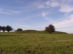
On the former parish boundary between Fosbury and Tidcombe lies the Iron Age hill fort of Fosbury Camp.