
Time zone IST (UTC+5:30) Area code 04735 | Elevation 117 m (384 ft) Local time Friday 4:03 PM | |
 | ||
Named for Marthoma Sleeha Syro-Malabar Church Weather 26°C, Wind SW at 10 km/h, 91% Humidity | ||
Thulappally is a small village in Perunad panchayath of Ranni tehsil in Pathanamthitta district of Kerala state, India. It is noted for the Syro-Malabar Church (Marthoma Sleeha Church) which comes under the Kanjirappally diocese.
Contents
- Map of Thulappally Perunad Kerala
- Etymology
- Geography
- Hindu temple
- Church
- Economy
- Climate
- Nearby schools and colleges
- Nearby hospitals
- Transport facilities
- Airports
- Railways
- Nearby places
- References
Map of Thulappally, Perunad, Kerala
Etymology
It is believed that in ancient times there were many small churches in the forest regions including Nilakkal and Thulappally as a result by the visit of St.Thomas in 52 AD. Places like Thulappally and Plappally in the forest were named after these churches. The head church of all these churches were known as Thalappally (Thala means head and pally means church) and which in course of time became "Thulappally".
Geography
Basically Thulappally is classified as Malanad (geographic division of Kerala) or high land with an altitude ranging from 117 m (384 ft) above mean sea level. The place is located near to the sacred forest regions (Poongavanam) of Sabarimala with comparatively less population. River Pamba flows westwards through the northern part of Thulappally.
Hindu temple
Vaikundapuram Sri Krishna Swami Temple, a Hindu shrine located on the banks of Pamba River with Lord Krishna as the principal deity is the main temple at Thulappally. The annual festival is hosted from May 10.
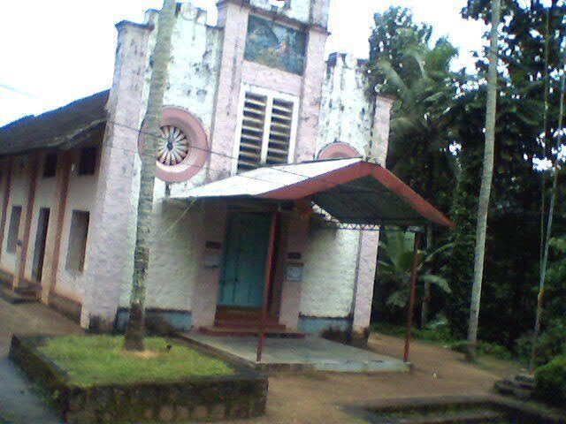
Church
Mar Thoma Sleeha Syro-Malabar Church, being an important landmark of the place is a pilgrimage church located here under the Syro-Malabar Catholic Eparchy of Kanjirappally. The St.Thomas's feast festivities held here every July attracts a number of devotees from in and around Kerala. Sharon Fellowship Church, Thulappally is a Pentecostal Church.
Economy
Majority of people depends upon the agricultural sector. Rubber is being cultivated widely and many rubber plantations are widespread in the populated regions. The hilly terrains here are suitable for its cultivation. Moreover, pepper, banana etc., are also cultivated. Many people works in abroad as well as in urban areas. The 'Malanadu development society' under Kanjirappally diocese has a rural electrification system named "Malanadu Mycro Hydel Power Project" (MHPP) at Thulappally. This small scale power project generates electricity from water bodies and supplies to about 250 families, shops and pilgrim centers.
Climate
A tropical climate is normally experienced here. The place receives significant rainfalls during the monsoon, with a short dry season. The average annual temperature rises to 27.3 °C. The months of June, July and August receives sufficient amount of rainfall, while the temperature falls to 21.7 °C in the month of January. Humidity normally increases in the months of March and April. The presence of thick forests helps to develop local thundershowers.
Nearby schools and colleges
Nearby hospitals
Transport facilities
There are well connected state highways and rural roads which makes transportation more flexible. Neriyamangalam - Pamba state highway (SH-44), one among the important roads to Sabarimala passes through Thulappally. Both state-owned (KSRTC) and privately operated buses provides service to Thulappally from places like Kottayam, Erumely and Kanjirappally. At times of Sabarimala pilgrimage (Mandala-Makaravilakku), thousands of vehicles passes through the place. In the past, the regions including Thulappally was not so easily accessible due to the absence of quality roads. But the transportation facilities improved when the Kanamala- Elavumkal highway was inaugurated.
Airports
Cochin International Airport is at distance of 125 km (78 mi) from here and Thiruvananthapuram international airport about 147 km (91 mi). A heliport is situated in Perunad which operates at times of Sabarimala pilgrimage.
Railways
Chengannur (59 km) Thiruvalla (63 km), Kottayam (65 km) and Changanassery (61 km) are the nearby railway stations.