
Topo map OS Landranger 119 Prominence 79 m | OS grid SK151510 Elevation 287 m | |
 | ||
Similar Alport Height, Shining Tor, Higger Tor, Derwent Edge, Axe Edge Moor | ||
Dovedale stepping stones thorpe cloud dj phantom 3 s
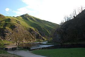
Thorpe Cloud is an isolated limestone hill (a reef knoll) lying between the villages of Thorpe and Ilam on the Derbyshire/Staffordshire border at the southern end of Dovedale. It is a popular hill amongst the many day-trippers who visit the area, and provides a fine viewpoint north up the dale and south across the Midland plain.
Contents
- Dovedale stepping stones thorpe cloud dj phantom 3 s
- Map of Thorpe Cloud Ashbourne UK
- Dovedale and thorpe cloud
- References
Map of Thorpe Cloud, Ashbourne, UK
Like much of the dale, including Bunster Hill on the opposite bank, it is in the ownership of the National Trust, and is part of their South Peak Estate. These Dovedale properties were acquired by the Trust in 1934.
In 1997, the writer Jeff Kent discovered that a double sunset could be seen against Thorpe Cloud from the top of nearby Lin Dale and, two years later, the phenomenon was first captured on film by the photographer Chris Doherty. The occurrence is visible in good weather on and around the summer solstice and perhaps beyond, when the sun sets on the summit of the hill, partially reappears from its steep northern slope and sets for a second and final time shortly afterwards. The precise event and its location are described in Kent's book The Mysterious Double Sunset.
Thorpe Cloud and Dovedale were used as locations in the 2010 film of Robin Hood, starring Russell Crowe. Thorpe Cloud can be clearly made out in several scenes towards the end of the film.
Thorpe Cloud also has a rifle range which local and national shooting clubs use.