
Name Thomas Jefferys | Died November 1771 | |
 | ||
Books An Account of the First Discovery, and Natural History of Florida | ||
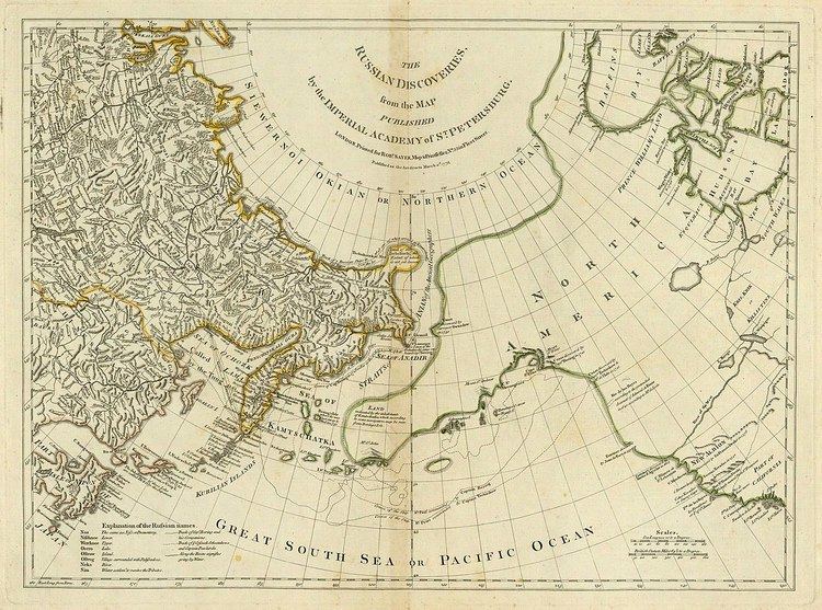
Thomas Jefferys (c. 1719 – 1771), "Geographer to King George III", was an English cartographer who was the leading map supplier of his day. He engraved and printed maps for government and other official bodies and produced a wide range of commercial maps and atlases, especially of North America.
Contents
Early work
As "Geographer to the Prince of Wales", he produced A Plan of all the Houses, destroyed & damaged by the Great Fire, which begun in Exchange Alley Cornhill, on Friday March 25, 1748. He produced The Small English Atlas with Thomas Kitchin, and he engraved plans of towns in the English Midlands.
Maps of North America
In 1754, Jefferys published a Map of the Most Inhabited Part of Virginia which had been surveyed by Joshua Fry and Peter Jefferson in 1751. The next year he published a map of New England surveyed by John Green, and in 1768 he published A General Topography of North America and the West Indies in association with Robert Sayer. In 1775, after his death, collections of his maps were published by Sayer as The American Atlas and The West-India Atlas.
In 1754, Jefferys participated in the controversy with the French on the boundary of Nova Scotia and Acadia, which arose in the time and context of Father Le Loutre's War, which is commonly held to have begun in 1749 and ended with the expulsion of the Acadians in 1755.
Jefferys post-humously in 1776 lent his name to The American Atlas: Or, A Geographical Description Of The Whole Continent Of America. It contains works by, amongst others, Joshua Fry and Peter Jefferson,
Maps of English counties
Jefferys commissioned surveys and published maps of several English counties. These were large-scale maps with several sheets for each county; in the case of Bedfordshire and Huntingdonshire the scale was two inches to one mile (1:31680).
After the death of Jefferys, these maps were re-issued by other map publishers such as William Faden.