
Prominence 220 ft (70 m) Easiest route Trail | Topo map USGS Hensonville Elevation 1,204 m | |
 | ||
Similar Blackhead, Black Dome, Windham High Peak, Graham Mountain, Mount Sherrill | ||
Hiking black dome via caudal camels hump and thomas cole mountain catskill mountains
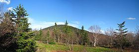
Thomas Cole Mountain is a mountain located in Greene County, New York. The mountain named for Thomas Cole (1801–1848), an artist who lived in the area, and is regarded as the founder of the Hudson River School.
Contents
- Hiking black dome via caudal camels hump and thomas cole mountain catskill mountains
- Map of Thomas Cole Mountain Windham NY 12454 USA
- References
Map of Thomas Cole Mountain, Windham, NY 12454, USA
Thomas Cole Mountain is part of the Blackhead range, and is the fourth highest peak of the Catskill Mountains. Thomas Cole is flanked to the east by Black Dome (3,990 feet or 1,220 metres), and to the west by Camel's Hump (3,530 feet or 1,080 metres).
Thomas Cole Mountain stands within the watershed of Schoharie Creek, which drains into the Mohawk River, the Hudson River, and into New York Bay. The south side of Thomas Cole drains into East Kill, and thence into Schoharie Creek. The north side of Thomas Cole drains into Batavia Kill, and thence into Schoharie Creek.
Thomas Cole Mountain is within New York's Catskill Park.