
Parent range Central Catskills Elevation 1,082 m | Topo map USGS Lexington Prominence 165 m Easiest route Hiking | |
 | ||
Similar North Dome, Halcott Mountain, Rusk Mountain, Vly Mountain, Fir Mountain | ||
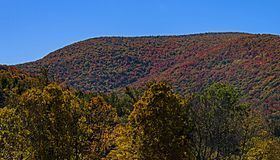
Mount Sherrill is a mountain located in Greene County, New York and is named after Eliakim Sherrill, and is part of the Catskill Mountains. Mount Sherrill is flanked to the east by North Dome, and to the west by Balsam Mountain.
Map of Mt Sherrill, Lexington, NY 12480, USA
Mount Sherrill stands within the watershed of the Hudson River, which drains into New York Bay. The northern slopes of Mt. Sherrill drain via Bennett Brook and Newton Brook into the West Kill, then into Schoharie Creek, the Mohawk River, and, finally, the Hudson River. The west side of Mt. Sherrill drains into Bushnellsville Creek, thence into Esopus Creek, and the Hudson River. The southeast side of Mt. Sherrill drains through Peck Hollow into Esopus Creek.
Mount Sherrill is contained within the Westkill Mountain Wilderness Area of New York's Catskill State Park. There is no hiking trail over the mountain, although an extension of the Devil's Path west from West Kill Mtn. has been contemplated.