
Population 556 (2011) Sovereign state United Kingdom Local time Thursday 5:51 AM | OS grid reference TL334371 Post town ROYSTON Dialling code 01763 | |
 | ||
Weather 11°C, Wind S at 18 km/h, 80% Humidity | ||
Therfield school sixth form college promotional video
Therfield is both a small village of approximately 4,761 acres (19 km²) and a civil parish (originally in Odsey Hundred and Royston Union) which sits upon the chalk range, three miles southwest of Royston, and six miles (10 km) northeast of Baldock and within the English county of Hertfordshire.
Contents
- Therfield school sixth form college promotional video
- Map of Therfield Royston UK
- Ancient history
- Today
- Church of St Mary the Virgin
- Therfield Chapel
- References
Map of Therfield, Royston, UK
Ancient history
The name Therfield is a variation of Tharfield and anciently Þurreweld. It is a theophoric placename referring to Thunor, and either means 'Thunor's Field' or 'Thunor's High place", from the same Germanic root that gives 'veldt'. It was inhabited long before the Anglo Saxons came, as the Icknield Way runs through the village, and Neolithic barrows have been found on Therfield Heath.
Today
Today Therfield is known as a very small village that is locally famous for its church, chapel and pub. The Nature Reserve of Therfield Heath lies a mile to the north of the village. From here on a clear day it is possible to see the Cathedral of Ely, over twenty miles to the north.
The Icknield Way Path passes through the village on its 110-mile journey from Ivinghoe Beacon in Buckinghamshire to Knettishall Heath in Suffolk.
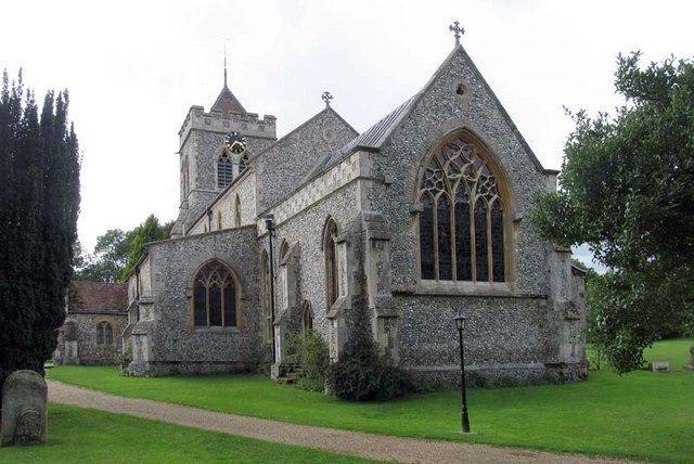
Church of St. Mary the Virgin
In Therfield the Church of St Mary the Virgin has stood the test of time. The most recent building was completed in 1878 and it replaced the church that had existed since the 13th Century which fell into such disrepair that it was in danger of collapsing. When it was replaced, the windows, pulpit and font were removed from the old church and built into the new structure. The tower contains six bells dating from 1597, 1608, 1626, 1656, 1689 with the most recent from 1707. For years these bells were not used and worship services were marked by the ringing of a bell dated 1862 that hung from a tree in a nearby field. The church register dates from the year 1538. Francis Turner (bishop) was buried here in the chancel in 1700. The church's original Stuart royal arms survives, and is unusual in that the inscription on the Garter is partly misspelt.
Therfield Chapel
Therfield Chapel was established as a congregation of Protestant dissenters (the "Independents") in 1836. The current Chapel was built subsequently, in 1854, and the Church eventually became known as Therfield Congregational Church, being affiliated to the Congregational Union who acted as trustees for the Church property. When in 1966 the Congregational Union was replaced by a body which espoused more liberal views, the Chapel seceded and became affiliated first to the Fellowship of Independent Evangelical Churches (FIEC), and then to the Evangelical Fellowship of Congregational Churches (EFCC).
In 1965, Allon Taffs was ordained as Pastor, after serving the church as Secretary/informal leader for some 10 years before. He remained until May 1993. After a period of interregnum, during which time the church was cared for and led by the elders and deacons, the Rev Mark Kingston was appointed as Pastor in August 1997. He served the church until he resigned in July 2002. Andrew Carter was appointed as Pastor in February 2006.