
Seat Caledon Time zone SAST (UTC+2) Area 3,232 km² Black african population 26.4% Native english speakers 3.9% | Wards 13 Municipal code WC031 White population 9.4% Native afrikaans speakers 73.6% | |
 | ||
Points of interest Hottentots Holland Mountains, Elgin - Western Cape, Cape Canopy Tour, Creation Wines, Paul Cluver Wines | ||
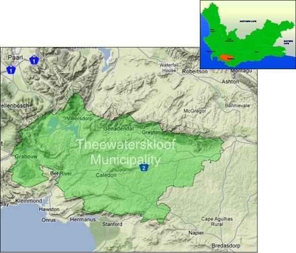
Theewaterskloof Municipality is a local municipality located within the Overberg District Municipality, in the Western Cape province of South Africa. As of 2007, the population was 108,790. Its municipality code is WC031. The enormous Theewaterskloof Dam, which provides water for Cape Town and the surrounding areas, is located in this municipality.
Contents
Map of Caledon, South Africa
Geography
The municipality covers an area of 3,232 square kilometres (1,248 sq mi) in the western interior of the Overberg region. It occupies the area between the Riviersonderend Mountains to the north and the Kogelberg and Kleinrivier Mountains to the south; to the west it stretches as far as the Hottentots-Holland mountains. The western area of the municipality is the Elgin Valley drained by the Palmiet River. The northern part is the valley of the Sonderend River including the Theewaterskloof Dam. The southeastern part is in the Overberg plain, drained by the Bot and Klein Rivers.
According to the 2011 census the municipality has a population of 108,790 people in 28,884 households. Of this population, 62.9% describe themselves as "Coloured", 26.4% as "Black African", and 9.4% as "White". The first language of 73.6% of the population is Afrikaans, while 16.9% speak Xhosa, 3.9% speak English and 3.6% speak Sotho.
The largest town in the municipality is Grabouw in the Elgin Valley, which as of 2011 has a population of 30,337. However, the municipal headquarters are situated in Caledon (pop. 13,020) on the plain. Between Grabouw and Caledon is Botrivier (pop. 5,505) at the base of the Houwhoek Pass. Villiersdorp (pop. 10,004) is located in the northern part of the municipality close to the Theewaterskloof Dam. Downstream from the dam along the Sonderend River are the villages of Genadendal (pop. 5,663), Greyton (pop. 2,780) and Riviersonderend (pop. 5,245).
Politics
]]
The municipal council consists of twenty-seven members elected by mixed-member proportional representation. Thirteen councillors are elected by first-past-the-post voting in thirteen wards, while the remaining twelve are chosen from party lists so that the total number of party representatives is proportional to the number of votes received. In the election of 18 May 2011 the Democratic Alliance (DA) obtained a majority of thirteen seats on the council.
The following table shows the results of the 2011 election.
The local council sends five representatives to the council of the Overberg District Municipality: three from the Democratic Alliance and two from the African National Congress.