
Established 1841 Local time Monday 6:22 PM | Postal code (street) 6848 Area code 028 | |
 | ||
Weather 22°C, Wind S at 11 km/h, 67% Humidity | ||
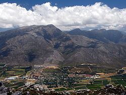
Villiersdorp is a town of approximately 10,000 people located in the Western Cape province of South Africa in the Overberg region.
Contents
Map of Villiersdorp, 6848, South Africa
Unlike most of the geographical region which specialises in wheat and canola farming, the Villiersdorp Valley is now agriculturally and in micro-climate more similar to the Elgin Valley and Grabouw since the building of the Theewaterskloof Dam, and thus also specialises in deciduous fruit farming and viticulture. The Theewaterskloof Dam, the largest dam in the Western Cape and 7th largest in South Africa and important water supply to Cape Town fills the majority of the valley floor. The Villiersdorp Co-Op is also the only place in South Africa that processes and dries persimmons. The 3 big packsheds in Villiersdorp, Betko, Arbeidsvreugd and Ideafruit, as well as the Villiersdorp Co-Op process the fruit grown in the area for export and transport to other parts of South Africa. The town is named after Field Cornet Pieter de Villiers, a local farmer who founded the settlement in 1843.