
Easiest route Exposed rock scramble Prominence 569 m | Topo map NTS 92G/14 Mountain type Stratovolcano Elevation 2,319 m First ascent 1912 | |
 | ||
Volcanic arc/belt Canadian Cascade ArcGaribaldi Volcanic Belt Similar Mount Garibaldi, Whistler Mountain, Blackcomb Peak, Castle Towers Mountain, Mount Price | ||
Hiking the black tusk british columbia outdoors
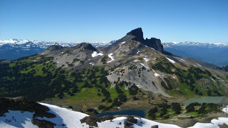
The Black Tusk is a stratovolcano and a pinnacle of volcanic rock in Garibaldi Provincial Park of British Columbia, Canada. At 2,319 m (7,608 ft) above sea level, the upper spire is visible from a great distance in all directions. It is particularly noticeable from the Sea-to-Sky Highway just south of Whistler, British Columbia. Distinctive and immediately identifiable, The Black Tusk is among the best known mountains in the Garibaldi Ranges of the Coast Mountains. The volcano is part of the Garibaldi Volcanic Belt which is a segment of the Canadian Cascade Arc, but it is not within the geographic boundary of the Cascade Range.
Contents
- Hiking the black tusk british columbia outdoors
- Map of The Black Tusk Squamish Lillooet D BC Canada
- The black tusk by helicopter squamish whistler british columbia
- IndigenousEdit
- GeologyEdit
- RecreationEdit
- References
Map of The Black Tusk, Squamish-Lillooet D, BC, Canada
The black tusk by helicopter squamish whistler british columbia
IndigenousEdit
To Squamish people, this mountain is known as t'ak't'ak mu'yin tl'a in7in'a'xe7en. In their language it means "Landing Place of the Thunderbird", speaking of the supernatural in7in'a'xe7en or Thunderbird. The jagged shape of the mountain and its black colouring are said to come from the Thunderbird's lightning. The same is true for Mount Cayley, another stratovolcano farther north.
GeologyEdit
The Black Tusk is considered to be the remnant of an extinct andesitic stratovolcano which formed between about 1.3 and 1.1 million years ago. Following glacial dissection, renewed volcanism produced the lava dome and flow forming its summit about 170,000 years ago. According to Natural Resources Canada, The Black Tusk was "perhaps the conduit for lava within a cinder-rich volcano. The loose cinder has eroded, leaving only the hard lava core." The exposed lava rock of the core is loose and friable. It is also black, giving the mountain its name and character. Cinder Cone, to the east of The Black Tusk, produced a 9 km (6 mi) long lava flow during the late Pleistocene or early Holocene.
The mountain currently hosts two significant glaciers, in large cirques carved into the northeastern and northwestern flanks of the broad cone below the lava pinnacle. Both glaciers start from about 2,100 m (6,890 ft) and flow northwards to below 1,800 m (5,906 ft). The glaciers are heavily covered in rocky debris due to the crumbling nature of the Tusk's rock.
The Black Tusk is a member of the chain of volcanic peaks that run from southwestern British Columbia to northern California. The peaks formed in the past 35 million years as the Juan de Fuca, Gorda and Explorer plates to its west have been subducting under the North American Plate at the Cascadia subduction zone.
RecreationEdit
The Black Tusk's lower flanks and south summit are a popular backcountry hiking and scrambling destination. Most hikers approach from the Taylor Meadows campground to the south near Garibaldi Lake, although there is a second route from the north that travels by way of Helm Lake. A third option approaches from the west, from a microwave relay tower located at about 1,800 m (5,906 ft) on the western flank, which is reached by a dirt road from the Cheakamus River valley.
The upper summit area at the top of the lava column can only be reached by scrambling up a short but exposed rock chimney to reach the south summit.[1] The true summit, only about a metre higher, lies just to the north across a precipitous drop. It is rarely climbed, requiring a rappel of about 10 m (33 ft) into a notch followed by a loose and dangerous reascent up the crumbling lava. On the northern side of the north summit stands an isolated and intimidating rock formation known as the "Bishop's Mitre", which is rumoured to be unclimbed.