
Topo map NTS 92G/14 Prominence 120 m | Elevation 1,910 m Mountain range Garibaldi Ranges | |
 | ||
Volcanic arc/belt Cascade Volcanic ArcGaribaldi Volcanic Belt Similar Pyroclastic Peak, Middle Finger, Vulcan's Thumb, Little Ring Mountain, The Table | ||
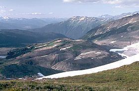
Cinder Cone is a cinder cone with a small crater on the west side of the Helm Glacier in Garibaldi Provincial Park in British Columbia, Canada. Cinder Cone is surrounded by cinder flats and its crater is filled with melt water during the summer. Cinder Cone is eroded easily by melt water during the spring, washing the pyroclastics into the Valley of Desolation. Cinder Cone produced a 9 km (6 mi) long lava flow during the early Holocene.
Map of Cinder Cone, Squamish-Lillooet D, BC, Canada
References
Cinder Cone (British Columbia) Wikipedia(Text) CC BY-SA