
 | ||
About thames gateway
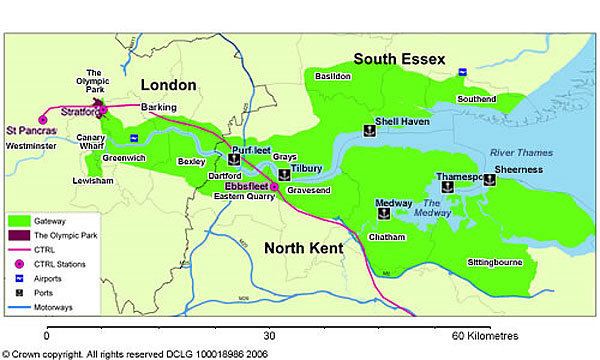
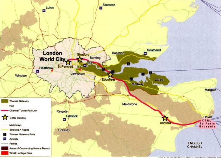
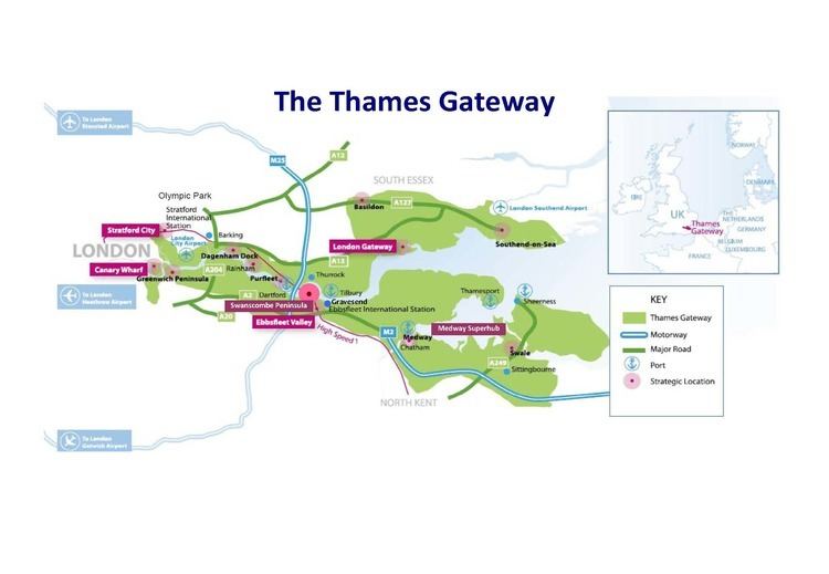
The Thames Gateway is an area of land stretching 70 kilometres (43 mi) east from inner east London on both sides of the River Thames and the Thames Estuary. The area, which includes much brownfield land was designated during the early years of the Blair ministry a national priority for urban regeneration, taking advantage of the development opportunities realised by the completion of the High Speed 1 (officially known as the Channel Tunnel Rail Link). First named by the UK government, which is unusual in the United Kingdom, uptake of and appreciation of the term varies, with many people preferring the traditional term, the Thames Estuary.
Contents
- About thames gateway
- Scope
- Profile
- Administration
- Former redevelopment zones
- Developments
- Environmental implications
- References
It stretches from Westferry in Tower Hamlets to the Isle of Sheppey/Southend-on-Sea and extends across three ceremonial counties. Development that is supplemental to councils' own development plans is delivered through Local Authorities (Councils), special purpose development corporations and local enterprise partnerships, all of which are eligible for grants from government departments funded by HM Treasury. Additional government funds were supplied to the Regional Development Agencies who supported some projects in the Gateway.
Scope
The Thames Gateway has a population of over 3 million and comprises generally Thameside belts of 16 local government districts:
Profile
The immediate settlements next to the types of land indicated, not taking the authorities as a whole, contains about half of the population of those authorities: 1.6 million people and contained in the 2000 survey some of the most deprived wards in the country, characterised by lack of access to public transport, services, employment and affordable quality housing, in particular having many overspill estates from earlier slum clearance and London's urban planning – examples being from Thamesmead to Southend on Sea.
Its boundary was drawn to capture the riverside strip that formerly hosted many land-occupying industries, serving London and the South East, whose decline has left a patchy legacy of dereliction and contaminated land. Striking precursor examples of development are those pioneered at Canary Wharf and on the Greenwich Peninsula, which the governments since 2000 have aimed to reflect across this area (having widespread comparable land use to those tracts of land).
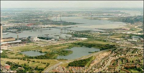
Its brownfield land, farmland and wild salt marshland has been seen by successive governments and planners as having potential to act as a catalyst for the regeneration and growth and for the social advancement of the area, helping to alleviate some of the growth pressures on London and the South East. Amid steep house price inflation and an economic boom in 2004 the government also expressed the firm belief that new private sector housing here and elsewhere would reduce that inflation.
Parts of the area are of settled character and/or already densely populated with little scope for housing developments: Southend-on-Sea, for example, is the eighth most densely populated district in the country outside London and mass expansion is not desired owing to the river at the south, the need for leisure space and animal habitat (mostly in the buffer zones separating communities) and an economic desire and legal demand to preserve the existing character of housing estates.
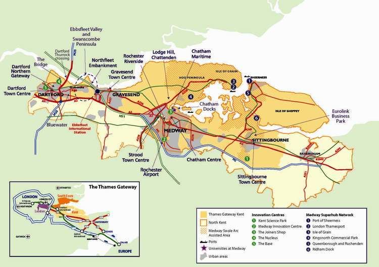
Administration
The Department for Communities and Local Government is responsible for co-ordinating the project.
The Thames Gateway project aims to improve the economy of the region through the development of marshland, farmland and brownfield land, through major transport infrastructure provision and the renaissance of existing urban conurbations.
Comparisons may be drawn with developments east of Paris along the Marne valley, which applied to a significantly smaller volume of land.
Formerly the development was in part delivered by the three regional development agencies: the London Development Agency (LDA – part of the Greater London Authority), the East of England Development Agency (EEDA) and the South East England Development Agency (SEEDA), as well as the national regeneration agency, English Partnerships.
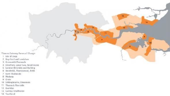
Former redevelopment zones
Formerly, the development was split into zones each with a different agency responsible for delivery. The zones were:
Developments
Before 2003 most conspicuous development was situated west of Beckton. There have been substantial housing schemes at Chafford Hundred, Chatham and Greenhithe and there is a large shopping centre at Bluewater.
Environmental implications
The Thames Gateway project proposes removing parts of and building on the North Kent Marshes, which are recognised as an Environmentally Sensitive Area by the Department for Environment, Food and Rural Affairs and are largely covered by Sites of Special Scientific Interest. There are also fears of increased erosion. Opponents of development have argued that promoting the ecological significance of the area by increasing public accessibility to threatened marshes and wetlands, with improved transport corridors, will cause further erosion.
Proposals for a large international airport on Cliffe Marshes were dropped from the government's white paper on air transport in 2003 after they were rejected by local residents, the local council, as well as conservation charities such as the RSPB. The plan, which would have required the raising the ground level by 15 m. was also rejected by the Confederation of British Industry as too expensive.
On the question of airport capacity, the Government has established the independent Airports Commission, led by Sir Howard Davies. The Commission is examining the nature, scale and timing of any requirement for additional capacity to maintain the UK's global hub status. The Aviation Policy Framework of March 2013 was an important piece in the jigsaw, setting out the principles which the Commission will take into account in working up its recommendations as it reports later in 2013 and in 2015. The options include outside possibility of a floating airport off the Isle of Sheppey.
The north of Kent has historically been a marshland area and is under great pressure by developers. In addition to the great variety of wildlife found on and along the Thames, these marshes offer invaluable natural flood protection for London area, ever under threat of flooding. A public inquiry found in favour of a rail freight depot proposed by ProLogis at Howbury in Slade Green. The proposal is to develop some of the Metropolitan Green Belt in the Crayford Marshes beside the present train depot. Roxhill has been seeking to modify the planned 149 acre "sustainable distribution park with modern multi modal connections" since at least 2015.
The London Development Agency perceives some strategic merit in the proposals, although local councillors are not convinced that the depot would truly encourage train movements as an alternative to road haulage. This scepticism arises partly because the railways in the area are heavily used by scheduled passenger trains, to the extent that Crossrail trains seem unlikely to progress to Dartford unless new tracks were laid to boost local rail capacity. ProLogis’ appeal was upheld by a 2007 Public Inquiry on the basis that the proposal supports the Energy policy of the United Kingdom and generates new jobs. Counter-arguments included that eventual warehouse occupiers would not use the site in the manner suggested, and that continuous noise levels would exceed WHO Community Noise Guidelines at some homes in Moat Lane. It was also found that night-time noise levels risked generating complaints from residents at Moat Lane and Oak Road.
Dave Wardle, of the Environment Agency, believes that "London and the Thames Estuary currently have one of the best tidal defence systems in the world". The Environment Agency assesses these systems will provide a high standard of protection well beyond 2030. However they also advise that future development in the Thames Gateway must go hand in hand with flood risk management, and take account of future plans for flood protection. The Agency insists it is important that effective flood risk management of the whole Estuary is not prejudiced by early decisions and development on the Gateway.
The Government has addressed some of these environmental concerns by designating the Thames Gateway as the UK's "eco-region", first announced in the 2007 Thames Gateway Delivery Plan. The objective of the "eco-region" is to protect and enhance the sustainability of the Thames Gateway, in terms of environmental quality, carbon reduction, and support for "green" economic development. This vision was elaborated in the 2008 Thames Gateway "eco-region prospectus", and implementation efforts are being led by the Homes and Communities Agency with support across government and local stakeholders.