
Founded 8 April 1603 Elevation 2,587 m (8,488 ft) Population 18,387 (2015) | Founded by Diego Gómez de Mena Area 108 km² Local time Tuesday 10:57 PM | |
 | ||
Time zone Colombia Standard Time (UTC-5) Weather 14°C, Wind N at 3 km/h, 89% Humidity | ||
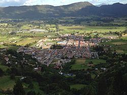
Tenjo is a municipality and town of Colombia in the Central Savanna Province, part of the department of Cundinamarca. The urban centre is located at an altitude of 2,587 metres (8,488 ft) on the Bogotá savanna. Tenjo is part of the Metropolitan Area of Bogotá and borders Chía, Madrid, Tabio, Funza, Subachoque and Cota.
Contents
Map of Tenjo, Cundinamarca, Colombia
Etymology
Tenjo in Muisca language literally translates "in the big mouth".
History
The area of Tenjo was inhabited by the Muisca in the times before the Spanish conquest. Tenjo was ruled by the zipa based in Bacatá. Ancient rock art has been discovered in Tenjo.
Modern Tenjo was founded on April 8, 1693 by Diego Gómez de Mena. On the 7 of May, 1637, it was decided that the first church of the town was to be built by Alonso Serrano Hernández after being hired by Juan de Vera, Cristóbal Gómez de Silva, Juan de Orejuela and Juan de Artieda. The church was completed on August 17, 1645. By the year of 1778, there was a population of 1,009 people and 211 families, excluding 983 other native people who inhabited Tenjo.
Economy
Tenjo's economy is mainly based on horticulture and livestock-breeding. Thanks to its relatively close position to Bogotá, Tenjo is starting to become part of its suburbs and with many schools being established here that have collaborated with this effect.