
 | ||
Trout on rapala mini fat rap ultra light minow mountain river tem tica promo video
The Temštica (Cyrillic: Темштица) is a river in Serbia and Bulgaria, a right tributary of the Nišava River. The Temštica itself is not very long, but receives a much longer tributary, the Visočica (Cyrillic: Височица), flowing from Bulgaria, making the Visočica-Temštica river system 86 km long.
Contents
- Trout on rapala mini fat rap ultra light minow mountain river tem tica promo video
- Tem tica tarzanov jaz 10 08 2013
- Temtica Toplodolska reka
- Visoica
- Temska
- References
Tem tica tarzanov jaz 10 08 2013
Temštica (Toplodolska reka)
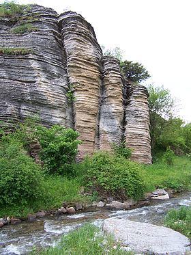
The Temštica or the Toplodoska reka (Cyrillic: Топлодолска река) originates from five streams from the Stara Planina mountain on the Serbo-Bulgarian border. Three major streams spring out from several peaks of Stara Planina: Midžor/Midzhur, Vražija Glava/Vrazha glava, Bratkova Strana and Gola Glava (Cyrillic: Миџор (Serbian) or Миджур (Bulgarian); Вражија Глава (Serbian) or Вража глава (Bulgarian); Браткова Страна; Гола Глава). They all join together near the village of Topli Dol, which gives the alternative name to the river. Temštica carved a canyon, popularly nicknamed "Little Colorado". The river continues to the northwest and receives the Visočica from the left.
Visočica
The Visočica or Visochitsa (Cyrillic: Височица) is 71 km long, originating in Bulgaria from the mountain of Berkovska planina, a part of Stara Planina, near Kom Peak, just a few kilometers away from the Serbian border. The river, in this section known also as Barlska reka from the name of the village of Barlya, flows to the south, reaching the Zabarde region of eastern Bulgaria and the northern slopes of the Gora mountain, where it turns west and enters the Visok depression at the village of Komshtitsa (Bulgarian: Комщица). Soon after it turns west, the Visočica crosses the Bulgarian-Serbian border.
The Visok depression is located between Stara Planina to the north and the Vidlič (or Vidlich) mountain to the south. It is elongated (divided into upper and lower sections) and sparsely populated: the villages of Izatovci, Slavinja (where it receives the tributary of Rosomačka reka from the right), Visoka Ržana (where it receives the tributary of the Dojkinička reka, also from the right), Rsovci, Pakleštica, Velika Lukanja and Zavoj, before it meets the Temštica.
In 1963 a huge landslide jammed the river, creating a natural earth dam (500 m long and 50 m high) which in turn created a lake that flooded the village of Zavoj. The natural lake was dried, the dam was consolidated and a hydroelectrical power plant was constructed (HE Zavoj) with the artificial Lake Zavoj (area 5,53 km²; altitude 612 m; depth 60 m) instead of the dried one. The village of Novi Zavoj was built on higher ground for the residents of the flooded Zavoj.
Serbian government began a project of conducting waters from Temštica into the lake Zavoj. Local population in the watershed of Temštica protested claiming that over 80% of the water was already taken out of Temštica which will result in an ecological catastrophe, especially in the canyon of Little Colorado. As a result of this, municipality of Pirot officially opposed the government's decision in 2004 and 2006, but the government insisted on continuing the project. In protest, population of the village of Temska boycotted the Serbian parliamentary elections in January 2007.
Temska
In the final, 15-km-long section after the confluence with the Visočica, the Temštica is also known as the Temska (Cyrillic: Темска). The river flows next to the village Zavoy and Monastery of Temska (with the small hydroelectrical power plant of the same name) and empties into the Nišava northwest of the town of Pirot.
The Temštica drains an area of 820 km², it belongs to the Black Sea drainage basin and it is not navigable.