
Location Bavaria Catchment area 212 km (82 sq mi) Max. length 6.5 km (4.0 mi) Area 8.934 km² Mean depth 36 m Islands Ringsee-Insel | Surface elevation 726 m Length 6.5 km | |
 | ||
Primary inflows Similar Wallberg, Alps, Wallbergbahn, Lake Starnberg, Tegernsee Abbey | ||
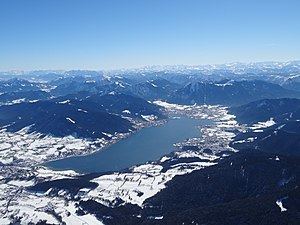
The Tegernsee is a Zungenbecken lake in the Bavarian Alps in southern Germany. The lake is the centre of a popular recreation area 50 kilometres (31 mi) south-east of Munich. Resorts on the lake include the eponymous Tegernsee, as well as Bad Wiessee, Kreuth, Gmund, and Rottach-Egern.
Map of Tegernsee, Germany
The lake is some 6.5 kilometres (4.0 mi) in length, with a width of 1.4 kilometres (0.87 mi) and an area of 8.934 square kilometres (3.449 sq mi). It reaches a maximum depth of 72.6 metres (238 ft), with an average depth of 36.3 metres (119 ft), and the normal water level is 725.5 metres (2,380 ft) above sea level. The lake flows into the River Mangfall, a tributary of the River Inn and thence the River Danube.
The buildings of the former Benedictine monastery of Tegernsee Abbey lie on the banks of the lake. Now in private hands, they are now known as Schloss Tegernsee.
The area around the lake is linked to Munich by rail through trains of the Bayerische Oberlandbahn, which, in the final part of their journey, travel over the tracks of the privately owned Tegernsee-Bahn. Pleasure boat services serve several points on the lake, and are operated by boats of the Bayerische Seenschifffahrt company.