
Palestine grid 187/194 | Governorate Tubas | |
 | ||
Weather 17°C, Wind NW at 8 km/h, 50% Humidity | ||
Tayasir (Arabic: تياسير, also spelled Tiaseer) is a Palestinian village in the Tubas Governorate in the northern West Bank. It is located 3 kilometers northeast of Tubas and 22 kilometers northeast of Nablus. Nearby localities include al-Aqabah to the east, al-Bikai'a to the northeast, Salhab to the north, 'Aqqaba to the west and ath-Thaghra to the southwest. According to the Palestinian Central Bureau of Statistics (PCBS), Tayasir had a population of 2,489 in 2007.
Contents
Map of Tayasir
History
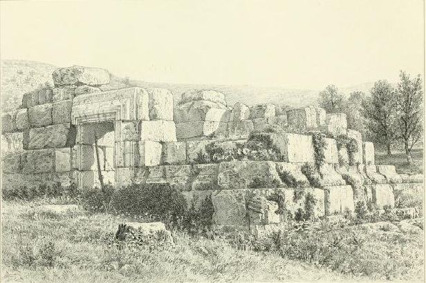
Settlement in Tayasir is believed to date back to the Canaanite era in Palestine, its name deriving from the Canaanite word Asheer meaning "pleasure" or "happiness." Several archaeological remains are located in the village, including an Ancient Roman palace, an olive press, several grottoes and the old mosque. An ancient road went through the village, and Byzantine ceramics have been found. It appears to have been called Asher by the Bordeaux Pilgrim, in 333-334 CE.
Medieval Arab geographer al-Muqaddasi, writing in the late 10th century CE, referred to the village as "Ta'asir", describing it as a place equally far from Nablus and Beisan.
In 1500 the Arab clans of Jabir and Taleb from as-Salt in Transjordan re-settled in the site and established the modern village, due to its strategic location and isolated arable land. In 1596 it appeared in Ottoman tax registers as "Tayasir", a village in the nahiya of Jabal Sami in the liwa of Nablus. It had a population of 39 households and 9 bachelors, all Muslim, and paid taxes on wheat, barley, summer crops, olive trees, occasional revenues, goats, beehives and a press for olives or grapes.
A building to the south of Tayasir, named el-Kusr, possibly a tomb, was first noted in 1869 and surveyed in 1874. French explorer Victor Guérin also explored the village in the same period.
In 1877 Lieutenant Kitchener, of the Palestine Exploration Fund survey team, reported the village deserted "owing to the heavy demands for taxes and conscription," while in 1881 Tayasir was described as a small village in a secluded and fertile valley, with good soil and arable land. To the south of the village there were old olive trees. The villagers cultivated the soil as far east as Wady Maleh, and had also good land near Yarza. Conder and Kitchener speculated that this village may have been the ancient site of the biblical Tirzah.
In 1900 landlord Hassan Hamad obtained the majority of Tayasir's lands due to the village residents' monetary debt to him. Thirty years later, most of the land was purchased by al-Batriyarkia al-Latinyah (Latin Patriarchate). Israel attempted to purchase the land following their capture of the West Bank in 1967 but the Patriarchate refused the offer.
Following the 1993 Oslo Accords, Tayasir came under the jurisdiction of the Palestinian National Authority (PNA) and later became a village council in 1997. Today the council consists of 11 members and is headed by Akram Dabaq.
Demographics
In the 1922 census of Palestine, conducted by the British Mandate authorities, Tayasir (called: Tiasir") had a population of 146, all Muslim. That rose to 192 inhabitants, all Muslim, except for 5 Christians, with 36 occupied houses at the time of the 1931 census. In Sami Hadawi's land and population survey in 1945, Tayasir's population was 260 and this figure nearly doubled in 1961, reaching 487. The Israel Central Bureau of Statistics, projected a population of 1,200 in 1987. In the Palestinian Central Bureau of Statistics' (PCBS) first official census in 1997, Tayasir had a population of 1,753 inhabitants. According to the 2007 census by the PCBS, the village's population was 2,489.
In the 1997 census, males constituted 50.6% of the population while females comprised 49.4%. Tayasir represents 5% of the Tubas Governorate's total population. Seven families make-up the majority of the village residents: Debik (17%), Abu Muhsen (15%), Wahdan (15%), Sbah (15%), Jabir (11%), Taleb (8%) and Abd al-Rasaq (7%). Other smaller families comprise 14% of the population.
Economy and land use
Tayasir's total land area amounts to about 26,000 dunams, of which roughly 500 make up the village's "built-up" area. About 5,000 dunams are classified as arable land, of which 3,545 are cultivated, mostly with field crops and fruit trees. The Israeli authorities have confiscated 15,875 dunams for security reasons and military use.
Agriculture is the largest economic sector, accounting for 82% of the active labor force. The second largest sector is the Israeli labor market accounting for 10% of workers. Between 2002 and 2006, the average household income dropped by 60% largely due to measures implemented by Israel as a result of the Second Intifada which began in 2000. In 2007 the PCBS recorded that there were 49 business establishments in Tayasir. According to ARIJ, these included 22 retail and grocery stores, two restaurants and one government-run health clinic. Most services are provided by nearby Tubas.