
Area 785 km² | Elevation 2,655 m | |
 | ||
Mountains Gerlachovský štít, Rysy, Lomnický štít, Kriváň, Kasprowy Wierch | ||
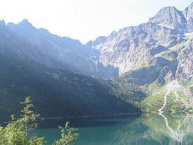
Backpacking hike in tatra mountains poland
The Tatra Mountains, Tatras or Tatra (Tatry either in Slovak ([ˈtatri]) or in Polish ([ˈtatrɨ])- plurale tantum), are a mountain range that form a natural border between Slovakia and Poland. They are the highest mountain range in the Carpathian Mountains. The Tatras should be distinguished from the Low Tatras (Slovak: Nízke Tatry) which are located south of the Tatra Mountains in Slovakia.
Contents
- Backpacking hike in tatra mountains poland
- Map of Tatra Mountains
- OverviewEdit
- Memberships and borderEdit
- ClimateEdit
- FloraEdit
- FaunaEdit
- SummitsEdit
- TrailsEdit
- Human engagementEdit
- Notable peopleEdit
- RankingsEdit
- References
Map of Tatra Mountains
The Tatra Mountains occupy an area of 785 square kilometres (303 sq mi), of which about 610 square kilometres (236 sq mi) (77.7%) lie within Slovakia and about 175 square kilometres (68 sq mi) (22.3%) on the territory of Poland. The highest peak, called Gerlach, at 2,655 m (8710 ft) is located north of Poprad. The highest point in Poland, Rysy, at 2,499 m (8200 ft) is located south of Zakopane.
The Tatras' length, measured from the eastern foothills of the Kobyli Wierch (1109 m) to the southwestern foot of Ostry Wierch Kwaczański (1128 m), in a straight line is 57 km (35 mi) (or 53 km (33 mi) according to some), and strictly along the main ridge, 80 km (50 mi). The range is only 19 km (12 mi) wide. The Tatras' main ridge leads from Huciańska Pass (905 m) in the west to Zdziarska Pass (1081 m) to the east.
The Tatras are protected by law by the establishment of the Tatra National Park, Slovakia and the Tatra National Park, Poland, which are jointly entered in UNESCO's World Network of Biosphere Reserves. In 1992 the Polish and Slovak parks were jointly designated a transboundary biosphere reserve by UNESCO in the World Network of Biosphere Reserves under its Man and the Biosphere Programme.
OverviewEdit
The Tatras are a mountain range of a corrugated nature, originating from the Alpine orogeny, and therefore characterized by a relatively young-looking lay of the land, quite similar to the landscape of the Alps, although significantly smaller. It is the highest mountain range within Carpathians. It consists of the internal mountain chains of:
The overall nature of the Tatras, together with their easy accessibility, makes them a favorite with tourists and researchers. Therefore, these mountains are a popular winter sports area, with resorts such as Poprad and the town Vysoké Tatry (The Town of High Tatras) in Slovakia created in 1999, including former separate resorts: Štrbské Pleso, Starý Smokovec, and Tatranská Lomnica or Zakopane, called also "winter capital of Poland". The High Tatras, with their 24 (or 25) peaks exceeding 2,500 m above sea level, together with the Southern Carpathians, represent the only form of alpine landscape in the entire 1,200 kilometres (746 miles) length of arc of the Carpathians.
Memberships and borderEdit
By the end of the First Polish Republic and the Polish border between the Kingdom of Hungary in the Tatras was not strictly defined. The Tatras became an unoccupied borderland. On November 20, 1770, under the guise of protection against the epidemic of plague in the Podolia, an Austrian army entered into Polish land and formed a cordon sanitaire, seizing Sądecczyzna, Spiš and Podhale. Two years later, the First Partition of Poland allocated the lands to Austria. In 1824, Zakopane good and Fish Creek Valley with Morskie Oko purchased from the authorities of the Austrian Hungarian Emanuel Homolacs. In 1867 formed the Austria-Hungary and the Tatra Mountains have become imaginary border between the two states of the monarchy, but the border itself still has not been exactly determined. In 1889, Count Władysław Zamoyski purchased at auction a good Zakopane (Zakopane and the Tatra Mountains, along with part of Morskie Oko). Due to numerous disputes over lands belonging in the late nineteenth century, attempts were made to the delimitation of the border. They did not bring effect in 1897, and the case went to an international court that on September 13, 1902 determined the exact course of the Austria-Hungary border in the disputed area.
ClimateEdit
The Tatras lie in the temperate zone of Central Europe. They are an important barrier to the movements of air masses. Their mountainous topography causes one of the most diverse climates in that region.
The average wind speed on the summits is 6 m/s.
On 19 November 2004, large parts of the forests in the southern Slovak part of the High Tatras were damaged by a strong wind storm. Three million cubic metres of trees were uprooted, two people died and several villages were totally cut off. Further damage was done by a subsequent forest fire, and it will take many years until the local ecology is fully recovered.
Temperatures range from −40 °C (−40 °F) in the winter to 33 °C (91 °F) in warmer months. Temperatures also vary depending on altitude and sun exposure of a given slope. Temperatures below 0 °C (32 °F) last for 192 days on the summits.
Highest precipitation figures are recorded on the northern slopes. In June and July monthly precipitation reaches around 250 mm (10 in). Precipitation occurs from 215 to 228 days a year. Thunderstorms occur 36 days a year on average.
Maximum thickness on the summit amounts to:
Peaks are sometimes covered with snow or ice throughout the year. Avalanches are frequent.
FloraEdit
The Tatra Mountains have a diverse variety of plant life. They are home to more than 1,000 species of vascular plants, about 450 mosses, 200 liverworts, 700 lichens, 900 fungi, and 70 slime moulds. There are five climatic-vegetation belts in the Tatras.
The distribution of plants depends on altitude:
FaunaEdit
The Tatra Mountains are home to many species of animals: 54 tardigrades, 22 turbellarians, 100 rotifers, 22 copepods, 162 spiders, 81 molluscs, 43 mammals, 200 birds, 7 amphibians and 2 reptiles.
The most notable mammals are the Tatra chamois, marmot, snow vole, brown bear, wolf, Eurasian lynx, red deer, roe deer, and wild boar. Notable fish include the brown trout and alpine bullhead.
The endemic arthropod species include a caddis fly, spider Xysticus alpicola and a springtail.
SummitsEdit
TrailsEdit
Orla Perć is considered the most difficult and dangerous public path in the entire Tatras, a suitable destination only for experienced tourists and climbers. It lies exclusively within the Polish part of the Tatras and was conceived in 1901 by Franciszek Nowicki, a Polish poet and mountain guide. More than one hundred individuals have lost their lives on the route since it was first established. The path is marked with red signs.
The highest point in the Tatra Mountains with access by labeled trails is Rysy.
Human engagementEdit
In the 18th and 19th centuries, the mountains were used for sheep grazing and mining. Many trees were cut down to make way for humans. Although these activities were stopped, the impact is still visible. Moreover, pollution from the industrialized regions of Kraków in Poland or Ostrava in Czech Republic, as well as casual tourism, cause substantial damage. Volunteers however initiate litter removal events frequently, on both sides of the border.
The Slovak Tatra National Park (Tatranský národný park; TANAP) was founded in 1949 (738 km2, 285 sq mi), and the contiguous Polish Tatra National Park (Tatrzański Park Narodowy) in 1954 (215.56 km2, 83.23 sq mi). The two parks were added jointly to the UNESCO Biosphere Reserve list in 1993.
In 2013 the International Union for Conservation of Nature threatened to cancel the Slovak TANAP's status of a national park because of the large investments (mainly in skiing infrastructure) in the park, which seriously interfere with the landscape and nature.
The 1999 film Ravenous was filmed in the Tatra Mountains.
In 2006, the Bollywood film Fanaa, portraying places in Kashmir, was filmed at Zakopane, mainly because of the risks associated with insurgency in Kashmir, as well due to some similarities in a mountain landscape.