
 | ||
Similar Taroko National Park, Qixingtan Beach, Eternal Spring Shrine, Liyu Lake, Chongde Station | ||
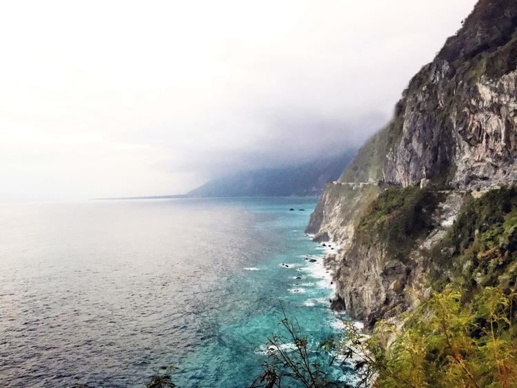
Qingshui Cliff (Chinese: 清水斷崖; Hanyu Pinyin: Qīngshuǐ Duànyá; Tongyong Pinyin: Cingshuěi Duànyá; Wade–Giles: Ch'ing1-shui3 Tuan4ya2) is a 21 kilometer length of coastal cliffs averaging 800 meters above sea level in Xiulin Township, Hualien County, Taiwan. The tallest peak, Qingshui Mountain, rises 2408 meters directly from the Pacific Ocean. The cliff is located at the southern part of the Suhua Highway that connects the counties of Yilan and Hualien in eastern Taiwan. It is considered to be a very scenic area and is the highest coastal cliff in Taiwan.
Contents
- Map of Ching shui Cliff Xiulin Township Hualien County Taiwan 972
- Political disputes
- Biogeographic significance
- Transportation
- References
Map of Ch'ing-shui Cliff, Xiulin Township, Hualien County, Taiwan 972
Political disputes
The depiction of Qingshui Cliff is featured in the newly issued passport of the People's Republic of China in 2012, a move that triggered protest from Taipei to Beijing.
Biogeographic significance
Qingshui Cliff can act as a dispersal barrier. It separates the eastern and western clades of brown tree frog (Buergeria robusta) as well as two sibling species of Takydromus lizards, T. viridipunctatus and T. luyeanus. In the latter case, the separation occurs over a single river, the Liwu River.
Transportation
Qingshui Cliff is accessible southwest from Heren Station of the Taiwan Railway Administration.