
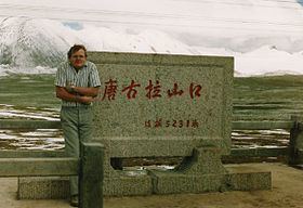
Elevation 5,231 m | ||
 | ||
Location Tibet Autonomous Region and Qinghai Province, China | ||
Tanggula pass and melting glacier in tibet
The Tanggu La, Tangla Pass, or Tanggu Pass (Chinese: 唐古拉山口; pinyin: Tánggǔlā Shānkǒu) is a wide mountain pass over 5000 metres elevation in China used by the Qinghai–Tibet Highway and Qinghai–Tibet Railway to cross the Tanggula Mountains. These mountains form part of the watershed separating the Yangtze River to the north and a zone of endorheic basins with internal drainage to the south. They also separate Tibet Autonomous Region and Qinghai Province.
Contents
- Tanggula pass and melting glacier in tibet
- Map of E59490E58FA4E68B89E5B1B1E58FA3 Amdo Nagqu China
- Tibet railway at tanggula pass
- References
Map of %E5%94%90%E5%8F%A4%E6%8B%89%E5%B1%B1%E5%8F%A3, Amdo, Nagqu, China
The Qinghai–Tibet Highway reaches its highest elevation, 5,231 metres (17,162 feet) in Tanggu Pass at 32°52′24″N 91°55′03″E. On August 24, 2005, rail track for the Qinghai–Tibet Railway was completed 28 kilometres to the WNW of the highway, reaching 5072 meters (16,640 feet) at 33°00′38″N 91°39′51″E. Tanggula Railway Station 1 km from this summit is—at 5,068 metres—the world's highest, 255 m higher than Ticlio, Peru.
The Qinghai-Tibet railway connects Xining, Qinghai Province to Lhasa. The 1,080-kilometre (670 mi) section from Golmud to Lhasa was opened on July 1, 2006. The rail cars have personal oxygen supplies to prevent altitude sickness.
For a satellite image showing the separate highway and railroad routes over the pass, click here:[1]. The rail route is highlighted in grey, with the 5,072 meter summit at the + crosshairs. The highway route is highlighted in yellow, with the 5,231 metre highway summit inside the largest box symbol.