
 | ||
Tours tv com tanggula mountains
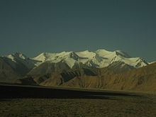
The Tanggula (Chinese: 唐古拉山, Tánggǔlāshān, or 唐古拉山脉, Tánggǔlāshānmài), Tangla, Tanglha, or Dangla Mountains (Tibetan: གདང་ལ་།, Gdang La, Dang La) are a mountain range in the central part of the Tibetan Plateau in Tibet. Administratively, the range is in the Nagqu prefecture of the Tibet Autonomous Region, with the central section extending into the nearby town of Tanggula and the eastern section entering the Yushu Tibetan autonomous prefecture of Qinghai province.
Contents
- Tours tv com tanggula mountains
- Map of Tangola Shanmai Golmud Haixi China
- Escape from tanggula mountains
- OverviewEdit
- References
Map of Tangola Shanmai, Golmud, Haixi, China
The Tanggula is the source of the Ulan Moron and Dangqu Rivers, the geographic headwaters of the Yangtze. The range thus functions as a dividing range between the basin of the Yangtze River in the north and the endorheic basins of north-eastern Tibet in the south.
Escape from tanggula mountains
OverviewEdit
The elevations of the main ridge average more than 5,000 m (16,404 ft). The Yangtze River originates in this mountain range and Peak Geladandong (at 6,621 metres or 21,722 feet, located within the town of Tanggula) is the tallest peak in the range.
The Qinghai-Tibet Highway and the Qinghai-Tibet Railway cross the Tanggula Mountains at Tanggula Mountain Pass. This is the highest point of the Qinghai-Tibet Railway, and the highest point of any railway in the world, at 5,072 metres (16,640 feet) above sea level. On account of the snow and occasional road accidents, highway closures and concomitant traffic delays are not uncommon.
The mountains lie within the Tibetan Plateau alpine shrub and meadows ecoregion.