
Time zone BST (UTC+6) Elevation 14 m Population 186,726 (2015) | Incorporated 1887 Area 35.22 km² Local time Sunday 6:10 PM Area code 0921 | |
 | ||
Upazila Tangail Sadar Upazila-Part, Delduar Upazila-Part Weather 28°C, Wind E at 6 km/h, 64% Humidity | ||
Beautiful tangail our city tangail
Tangail (Bengali: টাঙ্গাইল, [ʈaŋgail]) is a city of Dhaka Division in the central region of Bangladesh 98 km north-west of Dhaka, the capital. It is one of the important cities of Central Bangladesh and main urban area of Tangail District. The city is on the bank of Louhajang River.
Contents
- Beautiful tangail our city tangail
- Map of Tangail Bangladesh
- tangail bangladesh 03
- Etymology
- History
- Sports
- Administration
- Transport
- Traditional foods
- Parks
- Education
- Religion
- Notable residents
- References
Map of Tangail, Bangladesh
tangail bangladesh 03
Etymology
During early 19th century, horse carts were the main transportation medium for carrying goods and passengers in the present city area. A long line of horse carts used to stand at that time. There is a common belief that the name Tangail has been originated from the word tanga meaning horse carts.
History
Tangail was a popular local business centre since early 19th century. But the name came on focus when the headquarter of a subdivision of the Greater Mymensingh District was shifted in 1860 from Atia to there due to its fertility and high elevation near Louhajong River. At the same time, The subdivision was named as Tangail.
The Municipal Corporation or pourashava was established on 1 July 1887. During its establishment the town was composed of five wards.
} Afterwards, the pourashava was reshaped into four wards:
Iin 1988 it was subdivided into six wards:
After decisions for a few years, in 1999 the town was subdivided into 18 wards and gained its present shape. The first election of the town was held in November 1887. In that election eight ward commissioners from four wards were elected by direct vote of the citizens of the town. On the other hand, the then Subdivision Commissioner of Tangail, Shashi Shekhar Dutt, was appointed as the first administrator of Tangail municipality. There was no pakka street in this town then. No lamp post could be seen in the roads. In the 1890s the town was lacking safe water supply, too. The regional zamindarsand subdivision board came forward and helped financially to dig ponds, lakes and canals. Those sources served the local people with a safe water supply. In early 1900s, the pourashava authority lit the roads for the first time by kerosene lambs. The pourashava gradually became populated in the first half of the 20th century. At that time, many tube wells were set up in the town. The main way of transportation was horse carsin the town. People used cattle for transportation, too. The people of Tangail used to visit Kolkatathrough Charabari by launchand Dhakathrough Mymensingh. In the early 1930s, electricity line was first provided in the town. The rickshawsstarted to roll in town's streets. In the 1960s, pakka roads were constructed in the town. In the meantime, Tangail was directly connected to Dhaka by road. Many bridges and culvertswere constructed to develop the area. The town got water by pipelines at that time. In 1985 Tangail municipality was promoted to 'B Class' from 'C Class'. In 1989 the pourashava was promoted to 'A Class'. In 1990s, The town was financed by Asian Development Bankand Government of Bangladeshto develop water supply, sanitation, wastewater drainage, bus terminal, supermarkets and other infrastructure.
Sports
Cricket is the most popular sport in Tangail. Football and kabaddi are also popular. All important sports events of the city are held in Tangail Stadium which is beside Bhashani hall and Tangail Eid-gah. The stadium has hosted national events. It was the home venue of Bangladesh Football Premier League club Team BJMC. It was converted into a cricket stadium in 2015. First Division Cricket is regularly hosted in this venue.
Administration
The total area of Tangail city is 35.22 km2. The government of Bangladesh has planned to expand the city. After expansion it will have a proposed area of 81.75 km2. The city consists of 18 wards and 64 mahallas until 2016.
Karatia is the suburb of Tangail.
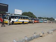
Transport
It takes approximately 1 hour and 55 minutes to reach Tangail from Dhaka city, via Kaliakair and Tongi. The distance is around 98 km. From Mohakhali (মহাখালী) bus terminal, several buses run to this city. Among them Nirala, Dhaleshwari, Jhatika and High Choice are notable.
Several trains are available from Dhaka to Tangail. Among them the most popular is "Sirajganj Express". Other notable intercity trains that stop in Tangail railway station are Padma Express, Ekota Express, Nilsagor Express, Silk City Express, Sundarban Express, Drutojan Express, Rangpur Express etc. Some local trains stop in the station, too. Those are Rajshahi Express, Rajshahi Mail, Rangpur Express, Fast Passenger, etc.
Traditional foods
Parks
Education
The literacy rate of the city area is 71.8%.
There are eight notable high schools in the city:
- Bindu Basini Govt. Boys' High School (established in 1880 by zamindar of Santosh of the famous Roy Chowdhury family)
- Bindu Basini Govt. Girls' High School (established in 1882 by zamindar of Santosh of the famous Roy Chowdhury family)
- Shibnath High School
- Vivekananda High School
- Police Lines High School
- Zila Sadar Girls' High School
- Santosh Jannabi Govt. High School
- P.T.I. High School
There are several colleges in the city.
- Major General Mahmudul Hassan College
- Kumudini College
- Mawlana Mohammad Ali Govt. College
- Govt. Sheikh Fazilatunnesa Mujib Mohila College
- Vivekananda College
- Police Lines College
Furthermore, Tangail Medical College and Tangail Polytechnic Institute are located here. There is a technological university named Mawlana Bhashani Science and Technology University in Santosh, Tangail.
Religion
The majority of Tangail city's people are Muslims (88.2%) like most other parts of Bangladesh. Other religious groups include Hindus (11.7%), Christians (.08%) and Buddhists (0.02%).