
District Tamenglong PIN 795141 Elevation 1,061 m Local time Sunday 11:06 AM | Time zone IST (UTC+5:30) Telephone code 03877 Area code 03877 Population 19,363 (2011) | |
 | ||
Weather 24°C, Wind SW at 8 km/h, 59% Humidity | ||
Lush garden in longmai noney village tamenglong
Tamenglong is an Indian town, district headquarter of Tamenglong district, in the state of Manipur. People of Zeliangrong community lives here. Rongmei language is predominantly spoken in and around the town.
Contents
- Lush garden in longmai noney village tamenglong
- Map of Tamenglong Manipur 795141
- Fresh oranges at the orange festival 2013 tamenglong manipur
- Geography
- Tamenglong District
- Places of interest
- Main tribes inhabitants
- Climate
- References
Map of Tamenglong, Manipur 795141
Fresh oranges at the orange festival 2013 tamenglong manipur
Geography
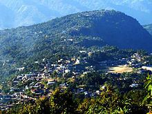
Tamenglong, located in the western part of the state, lies on the hilltop that descends Barak River. It is 160 km west of Imphal, Manipur's capital city.
Tamenglong District
Tamenglong District consists of virgin forests, exotic orchids, rare and endangered plants, and wildlife. The forests can be grouped as tropical evergreen forest, subtropical forest and bamboo brakes. The dense tropical evergreen forests are located along the sides of rivers flowing in the district. Tamenglong is called the land of the hornbill. Great pied hornbill (Buceros bicornis homrai), Indian pied hornbill (Anthracoceros malabaricus malabaricus) species are found here. A number of exquisite orchids are also found here. They are epiphytic, lithophytic and terrestrial in nature.
Places of interest
Tamenglong district of Manipur has a topography of irregular undulation with turbulent waters, waterfall, dark caves, lakes, dense tropical forest.
Main tribes (inhabitants)
Climate
Köppen-Geiger climate classification system classifies its climate as humid subtropical (Cwa). Tamenglong is a highland which makes the temperatures cooler. The warmer months are extremely rainy. July receives most rain while December is the driest.