
Population 549 (2011) Postal code 4340 | Postcode(s) 4340 | |
 | ||
Location 64 km (40 mi) from Brisbane25 km (16 mi) from Ipswich | ||
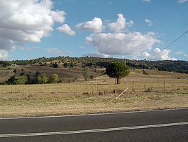
Tallegalla is a locality in Ipswich, Queensland, Australia. At the 2011 Australian Census the locality recorded a population of 549. The origin of the suburb name is from the Latin word Talegalla which was the genus name for the Brush-turkey. John Dart, the first to settle in the area, choose the name when he applied to open a postal receiving office at his farm.
Contents
Map of Tallegalla QLD 4340, Australia
Geography
Most of Tallegalla lies within the Lockyer Creek catchment area, but small portion exist in both the Brisbane River and Bremer River catchments. In the west of Tallegalla, the terrain is elevated by the Little Liverpool Range.
History
In 1879, a school was constructed. The Marburg railway line, which operated from 1911 to 1964, had a station at Tallegalla.
Heritage listings
Tallegalla has a number of heritage-listed sites, including: