
Phone number 0428-88-0211 Population 587 (1 Nov 2015) | Region ChūbuTōkai Area 101.3 km² Local time Wednesday 6:58 PM | |
 | ||
Weather 8°C, Wind W at 6 km/h, 96% Humidity Points of interest Nanatsuishisan, Tanbatenpyo, Shikakurayama, Ashizawayama | ||
9 24 15 1999 suspension bridge fureai no hashi tabayama yamanashi japan
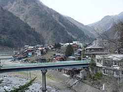
Tabayama (丹波山村, Tabayama-mura) is a village located in Kitatsuru District, Yamanashi Prefecture, Japan. As of November 2015, the village had an estimated population of 587 and a population density of 5.79 persons per km². The total area was 101.30 square kilometres (39.11 sq mi).
Contents
- 9 24 15 1999 suspension bridge fureai no hashi tabayama yamanashi japan
- Map of Tabayama Kitatsuru District Yamanashi Prefecture 409 0300 Japan
- Geography
- Surrounding municipalities
- History
- Economy
- Highway
- References
Map of Tabayama, Kitatsuru District, Yamanashi Prefecture 409-0300, Japan
Geography
Located in the northeastern corner of Yamanashi Prefecture, the village is very mountainous. Most of the village is covered by forests, and is located in Chichibu-Tama-Kai National Park.
Surrounding municipalities
History
During the Edo period, all of Kai Province was tenryō territory under direct control of the Tokugawa shogunate. During the cadastral reform of the early Meiji period in July 1, 1889, the village of Tabayama was created within Kitatsuru District, Yamanashi Prefecture. Most of the land in the village has been protected watershed, providing water for the Tokyo Metropolis since 1901, under the control of Tokyo Metropolitan Government Bureau of Waterworks. Discussions have taken place to merge Tabayama with neighboring Kōshū.
Economy
The economy of Tabayama is primarily based on forestry and agriculture.