
Surface area 4.25 km (1.64 sq mi) Surface elevation 526 m Lake type Reservoir | Max. depth 142 m (466 ft) Area 4.25 km² Outflow location Tama River | |
 | ||
Primary inflows | ||
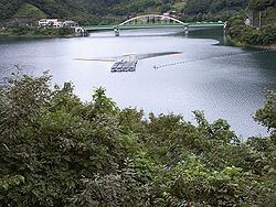
Lake Okutama (奥多摩湖, Okutama-ko) is in Tokyo and Yamanashi Prefectures in Japan. Lying above the Ogōchi Dam, it is also known as the Ogōchi Reservoir. Lake Okutama is an important source of drinking water for Tokyo.
Contents
- Map of Lake Oku tama Japan
- Day trip from tokyo okutama and lake okutama hiking
- DescriptionEdit
- Ogchi DamEdit
- References
Map of Lake Oku-tama, Japan
Day trip from tokyo okutama and lake okutama hiking
DescriptionEdit
The lake occupies part of the town of Okutama in Nishitama District, Tokyo and the village of Tabayama in Kitatsuru District, Yamanashi.
The Taba (Tama) River feeds Lake Okutama at its western end. From the southwest, the Kosuge River also flows into the lake. The Tama River drains the lake at the eastern end. The surroundings are famous for cherry blossoms in the spring.
Ogōchi DamEdit
References
Lake Okutama Wikipedia(Text) CC BY-SA