
Prominence 721 m (2,365 ft) Elevation 2,961 m | ||
 | ||
Listing Alpine mountains 2500-2999 m Similar Trois‑Évêchés, Grande Séolane, Blayeul, Les Monges, Mont Pelat | ||
T te de l estrop ao t 2014
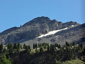
The Tête de l'Estrop is a mountain of the French Prealps located in Alpes-de-Haute-Provence, France. It is the highest peak of the Provence Alps and Prealps.
Contents
- T te de l estrop ao t 2014
- Map of TC3AAte de lEstrop 04340 MC3A9olans Revel France
- T te de l estrop 2961m survol en drone bebop 2 20 juillet 2016 hd
- GeographyEdit
- Access to the summitEdit
- MapsEdit
- References
Map of T%C3%AAte de l'Estrop, 04340 M%C3%A9olans-Revel, France
T te de l estrop 2961m survol en drone bebop 2 20 juillet 2016 hd
GeographyEdit
Administratively the mountain is divided between the French communes of Prads-Haute-Bléone (southern slopes) and Méolans-Revel (vallon du Laverq, northern slopes).
Access to the summitEdit
The easiest route to the summit starts from La Foux d'Allos, a ski resort in the commune of Allos, which reaches the top through the eastern slopes of the mountain.
MapsEdit
References
Tête de l'Estrop Wikipedia(Text) CC BY-SA