
Population (2015) 657 Local time Sunday 3:42 PM | Area 116.6 km² | |
 | ||
Weather 9°C, Wind W at 13 km/h, 42% Humidity Points of interest Val d'Allos, Val d'Allos ‑ La Foux, Val d'Allos Loisirs Développement | ||
Allos spiritual battle full album brazilian power metal
Allos is a French commune in the Alpes-de-Haute-Provence department in the Provence-Alpes-Côte d'Azur region of southeastern France.
Contents
- Allos spiritual battle full album brazilian power metal
- Map of 04260 Allos France
- Konstantinos pantzis nikos souliotis feat antypas allos stixoi spyros giatras
- Geography
- Geology
- Relief
- Environment
- Natural and technological risks
- Toponymy
- History
- Heraldry
- Administration
- Education
- Demography
- Overview
- Agriculture
- Industry
- Service activities
- Culture and heritage
- Civil heritage
- Religious monuments
- The Church of Notre Dame de Valvert
- Notable people linked to the commune
- References
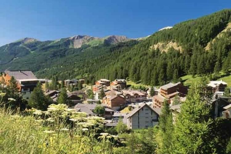
Map of 04260 Allos, France
Allos is a high mountain commune in the southern Alps. The commune experienced a significant rural exodus in the 19th century, following the population movement of the department. Then the town was overwhelmed for eighty years by winter sports: the construction of accommodations and ski-lifts has changed the landscape and the mountain urbanisation. The economy was profoundly altered with almost all jobs being found in tourism. Traditional agricultural activities persisted only marginally.
Historically Allos, located in the valley of the Verdon, has long been linked to the Ubaye Valley: first at the time when Ubaye belonged to the States of Savoy (from 1388 to 1713) then after it became part of France it continued to be administered across the Col d'Allos (impassable in winter). Even after the Revolution, it was attached to the Barcelonnette district. It was not until 1985 that it was (administratively) turned towards the valley by accepting the connection to the Canton of Colmars.
The inhabitants of the commune are known as Allossards or Allossardes
Konstantinos pantzis nikos souliotis feat antypas allos stixoi spyros giatras
Geography
Allos is located some 12 km south of Barcelonnette and some 100 km north-west of Nice at an altitude of 1425 m. The Allos valley is traversed by the Verdon which has its source in the Foux d'Allos in the Sestriere valley at 2500 m altitude.
Access to the commune is by the D908 road: a tortuous road running off the D902 south of Barcelonette which passes through the heart of the commune and the village before continuing south to Colmars.
Located at the edge of the Mercantour National Park, the country of Upper Verdon and the Allos valley offers landscapes of great beauty: from the famous Lac d'Allos (Allos Lake) which is the largest mountain lake in Europe to the waterfall of La Lance, near Colmars-les-Alpes. The flora is rich and varied depending on the altitude: larch, spruce, fir as well as Alpine clematis, peonies, and Martagon.
Geology
The mountains around Allos are composed of black schist.
Relief
All around Allos from the Col d'Allos (2247 m, north of the village) and in a clockwise direction:
The peaks to the west of Allos belong to the Massif des Trois-Évêchés (Three bishoprics mountains) while to the east are the secondary mountains of Mount Pelat.
Environment
The town has 1,869 hectares of woods and forests.
Natural and technological risks
None of the 200 communes of the department is in a no-risk seismic area. The Canton of Allos-Colmars is in zone 1b (low risk) according to the deterministic classification of 1991 and based on historical earthquakes. It is in Zone 4 (medium risk) according to the ECS probability classification of 2011. Allos commune is also exposed to four other natural hazards:
Allos commune is exposed to a risk of technological origin - i.e. the risk of dam breakage on the hill reservoir of Tardée above the Foux-d'Allos ski-station.
The prevention plan for foreseeable natural risks (PPR) for the commune was approved in 1998 for flood risk, landslide, and avalanche; and a Communal Dossier on Major Risks (DICRIM) has existed since 2010.
The commune has been the location of several natural disasters: an earthquake in 1984, flooding and mudslides in 1994 and 2003. In November 2012 a landslide cut off the only access road to the hamlets of Bouchiers and Le Collet - a cut that lasted more than seven months.
Toponymy
The locality appears for the first time in texts from 1056 under the name of ad Alodes which means Allods in Occitan. A Pre-Gallic hypothesis has also been considered more in line with local phonetic rules such as Fénié. The name Allos derived then from Al- designating "rocks". The form Alodes would be in this case a bad romanization. The commune is called Alòs in Occitan Vivaro-Alpine dialect.
The name of the station La Foux-d'Allos means "narrow gorges" between the surrounding peaks.
History
The name of the people located in the upper valley of the Verdon is not certain but it may be the Eguiturii. At the end of the Roman Empire the upper valley of the Verdon depended on the civitas and the bishopric of Thorame.
It is possible that the first village was built around Notre-Dame-du-Valvert in the High Middle Ages. It would then have been perched at Banivol before moving lower in the 12th to 13th centuries. The village was cited in 1056 and had its own consulat from 1233, by privilege from the Comte de Provence, and a Fair. Allos belonged to the Counts of Provence until 1388 then, with the Ubaye Valley and Nice, passed to the Counts of Savoy until 1713. From that time until the beginning of the French Revolution Allos was administratively attached to Barcelonnette. The first division of Basses-Alpes included Allos in the Barcelonnette dustrict.
During the Wars of religion the Duke of Lesdiguières bombarded the town without taking it in 1597. He had brought his army through the Col de Thuiles.
The peculiarities of the Allos community, which occupies several deep valleys and whose habitat is dispersed across multiple villages, led to the creation of three parishes in the 17th century: one in La Foux, one in Bouchiers, and one in Baumelle. A large number of chapels were also built: 29 in total throughout history.
Several major fires ravaged the town in 1718, 1747, and 1769.
During the French Revolution the commune had a patriotic society which was created at the end of 1792.
In the 20th century Allos became a tourist town: in 1935, the ski-lifts were built at Seignus and Foux. In the 1970s, when winter sports become mass entertainment, more ski resorts were built in two hamlets. It was not until 1985 qu'Allos turns towards the valley by integrating with the Arrondissement of Castellane.
Heraldry
Canting arms: Allos, in Latin Allosium, in Provençal Alouès. Alo-west Wing-bone.
Administration
List of Successive Mayors
(Not all data is known)
The election of the City Council in March 2008 was the subject of an appeal to the administrative court of Marseille; the judgment led to new elections in September.
Education
The town has had a computerized library since 2004 (See online catalogue) in the Haut-Verdon library network (Communauté de communes du Haut-Verdon-Val-d'Allos) and has two primary schools (one at Allos and one in La Foux d'Allos).
Demography
In 2009 the commune had 691 inhabitants. The evolution of the number of inhabitants is known through the population censuses conducted in the commune since 1793. From the 21st century, a census of communes with fewer than 10,000 inhabitants is held every five years, unlike larger towns that have a sample survey every year.
sources = Édouard Baratier, Georges Duby & Ernest Hildesheimer
Sources : Ldh/EHESS/Cassini until 1962, INSEE database from 1968 (population without double counting and municipal population from 2006)
Overview
Allos is a high mountain commune whose main resource is tourism - hiking in the summer - but especially winter sports.
In 2009 the active population was 381 people including 20 unemployed (46 in late 2011). These workers are mostly employed (65.7%) and the vast majority work in the commune (nearly 91%). This can be explained by the predominance of the tourism sector which provides sufficient employment to the people of the commune. As a result, most of the people of the commune work in services and administration (97% at the end of 2010). Industry, construction and agriculture no longer use a residual share of the people.
At 1 January 2011 establishments active in the commune were mainly shops and services (215 of 326 establishments) and health and social administrative sector, (69).
Agriculture
At the end of 2010 the primary sector (agriculture, forestry, fisheries) had 15 different establishments with 19 employees including 1 establishment employing 3 workers.
Most of the survey data from the Ministry of Agriculture are subject to statistical secrecy which indicates low numbers and extent of cultivated land. In 2000 three farms used a utilized agricultural area (UAA) of 281 hectares - the area has been in sharp decline since 1988 (406 hectares).
Industry
In late 2010 the secondary sector (industry and construction) had 27 establishments mainly crafts (22 companies with no employees). The sector employs 11 people.
Service activities
The commune has two ski-stations:
Summer tourism is also developed with different lakes and mountain walks.
In late 2010 the tertiary sector (trades and services) had 215 establishments (with 434 employees) plus 69 administrative establishments and the health and social sectors (employing 52 people).
According to the Department of Tourism, tourism activity is very important for the commune with more than 5 tourists per resident and with a large capacity for accommodation. Several accommodation facilities for tourists exist in the commune:
It is nevertheless second homes that weigh more heavily on the capacity with almost 5,000 second homes (4,900 out of 5,340 dwellings).
Culture and heritage
The commune contains a very large number of sites that are registered as historical monuments. For a complete list with links to descriptions (in French) and photos click here. Lists below are abridged showing the main sites.
There is also a very large number of items registered as historical objects located at:
For a complete list of all historical objects with links to descriptions (in French) and photos click here.
Civil heritage
There are still remnants of medieval structures:
Examples of later structures registered as historical monuments:
Religious monuments
The churches and rural chapels are in a simple alpine style imposed by the climate. Notre-Dame-de-Valvert at Allos is a good example from the 13th century.
The extent of the commune with its large population the 19th century, when the parishes and their branches were under the Concordat plan, made communications difficult due to the terrain and snow in winter. All these conditions justified the creation of several parish churches which are now registered as historical monuments:
The commune also has many chapels which are also registered as historical monuments:
The Church of Notre-Dame-de-Valvert
The parish church of Allos dates from the first half of the 13th century and was listed as a historical monument in 1846 for the parts dating from the second half of the 9th and 10th centuries.
It is built in Brickwork in a regular way with a chevet made of a single semicircular Apse, vaulted in cul-de-four. Like all churches in alpine style only the south wall has three bays which are semicircular.
The decor is unusual with walls decorated with a series of small arcs. The decor is a late development (13th century) of the Lombard band. The capitals are adorned with foliage, except for the facade, and decorated with masks (Lombard influence) and animals. The front is reinforced by two buttresses at the corners.
Raymond Collier identifies several characteristics of Notre-Dame-de-Valvert different from the communal type of alpine Romanesque:
It was damaged at the beginning of the 17th century and again in 1697 by the war: the second time the Savoyards caused the collapse of the tower. The vault of the choir was repaired between that date and 1723 before the bell was worn out in 1727. The Allos fire on 15 November 1747 reached the church and caused extensive damage. A new tower was built in 1751. Major restoration work took place between 1894 and 1896: the bottom of the facade and the Mur gouttereau (guttered walls), the bay windows, and the Buttresses were completely rebuilt and the roof of the third bay itself was also completely rebuilt. The rest of the arches and the bell tower were rebuilt in 1899-1904 with various repairs, when the murals disappeared.