
Elevation 6,983 ft (2,128 m) | Country United States | |
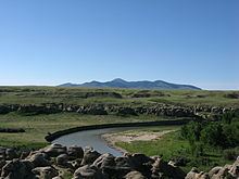 | ||
Climbing west butte sweet grass hills montana usa 2015
The Sweet Grass Hills (Blackfoot: kátoyissiksi, Cheyenne: vé'ho'ôhtsévóse, Salish: ččaɫalqn , "three peaks" ) are a small group of low mountains rising more than 3,000 feet above the surrounding plains southwest of Whitlash, Montana in Liberty and Toole County, Montana. The tallest point in the hills is West Butte at 6,983 feet (2,128 m). Quite prominent in the local area, they are clearly visible from US Highway 2 to the south and can sometimes be seen as far north as the Crowsnest Highway (Highway 3) near Medicine Hat in Alberta. Other named peaks in the small group are Gold Butte (6,512 feet), East Butte (with two peaks, the taller of which at 6,958 ft), and Mount Lebanon (5807 ft). The Sweet Grass Hills are an example of the island ranges that dot the central third portion of the state of Montana. These island ranges, completely surrounded by the 'sea' of plains and not geographically (or often geologically) part of the Rocky Mountains to the west, are "biological hotspots", containing more species than the prairie below.
Contents
- Climbing west butte sweet grass hills montana usa 2015
- Map of Sweet Grass Hills Montana 59444 USA
- Memorial day sweet grass hills 2014
- Formation and natural featuresEdit
- Cultural significanceEdit
- References
Map of Sweet Grass Hills, Montana 59444, USA
Memorial day sweet grass hills 2014
Formation and natural featuresEdit
The hills were formed in the early Paleogene period, and geologically are known as stocks - intrusive igneous rock forced up from below and solidified. Because of uplift and erosion, the overlying rock formations have disappeared. The upper slopes of the hills have not been glaciated and would have stood above the ice sheet that covered the area during the last ice age. Since the Sweet Grass Hills are at a higher elevation than the surrounding prairie, temperatures are cooler and precipitation is higher. Forested areas, consisting mainly of Douglas fir, are therefore able to grow on the hills' slopes.
Cultural significanceEdit
The Sweet Grass Hills are a sacred site of the Blackfoot aboriginal people who live on both sides of the 49th parallel north which forms the Canada–United States border. The Hills were the site of a battle between Native people and wolfers in 1872. The Sweetgrass Hills Treaty of 1887 was signed between the Blackfeet and the United States, ceding 17,500,000 acres of land to the US Government, and dividing the remaining 6,000,000 into three separate reservations – The Blackfeet, Fort Belknap and Fort Peck. This is often referred to as the Sweetgrass Hills Treaty/Agreement and was ratified by congress in 1888. In 1993, the Hills were listed as one of America's Most Endangered Places. Mineral claims were staked here by Manhattan Minerals in 1995.