
District Nordmøre Area rank 40 in Norway Area 1,713 km² Local time Friday 4:46 PM | Administrative centre Sunndalsøra Demonym(s) Sunndaling Population 7,205 (2010) Official language form Norwegian Language | |
 | ||
Weather 1°C, Wind S at 14 km/h, 55% Humidity Points of interest Dovrefjell–Sunndalsfjella National Park, Innerdalstårnet, Sunndal Rural Museum, Leikvin Heritage Park, Vinnufossen | ||
Sunndal is a municipality in the Nordmøre region located in the northeast part of Møre og Romsdal county, Norway. The administrative center of the municipality is the village of Sunndalsøra. Other villages include Gjøra, Grøa, Hoelsand, Jordalsgrenda, Romfo, Ålvund, Ålvundeidet, and Øksendalsøra.
Contents
Map of Sunndal, Norway
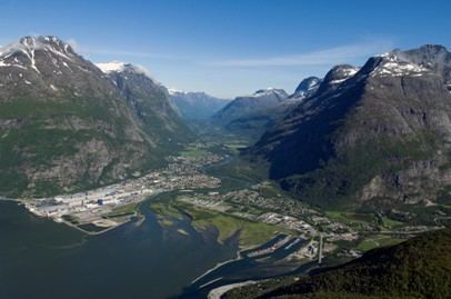
With an area of 1,712 square kilometres (661 sq mi), it is the largest municipality in Møre og Romsdal county. The important occupations in Sunndal include industry (with Hydro Aluminium Sunndal as the biggest employer), public services, retail, and farming.
General information
Sunndal was established as a municipality on 1 January 1838 (see formannskapsdistrikt). The northern part of the municipality was separated in 1854 as the new municipality of Øksendal. On 1 January 1960, Ålvundeid (which was originally a part of Øksendal) and Øksendal were merged back into Sunndal. On 1 January 1965, the Ålvund-Ålvundfjord area of Stangvik (population: 508) was transferred to Sunndal.
Name
The Old Norse form of the name was Sunndalr. The first element is sunnr which means "southern" and the last element is dalr which means "valley" or "dale". Before 1870, the name was written Sunddalen (or Sunndalen); during the period from 1870–1917, it was spelled Sundalen; and since 1918, it has been spelled Sunndal.
Coat-of-arms
The coat-of-arms is from modern times. They were granted on 12 April 1983. The arms show a Norwegian wormwood (Artemisia norvegica) plant in white on a green background. This species has its main European distribution in Sunndal and Oppdal in the Dovrefjell-Sunndalsfjella National Park and in Trollheimen landscape protected area. Small populations also in Ryfylke, Scotland, and the Ural Mountains, with another subspecies in the mountains of Northern America. It can be found in abundance in many places in the mountains of Sunndal well above tree line.
Churches
The Church of Norway has four parishes (sokn) within the municipality of Sunndal. It is part of the Indre Nordmøre deanery in the Diocese of Møre.
Geography
Sunndal is bordered on the west by Nesset Municipality and Tingvoll Municipality, on the north by Surnadal Municipality, on the east by Oppdal Municipality (in Sør-Trøndelag county) and on the south by Lesja Municipality (in Oppland county).
In the southern part of the municipality lies the Dovrefjell–Sunndalsfjella National Park, home to a plentiful amount of impressive muskox. In the northern part is the Trollheimen and Innerdalen landscape protection areas.
The municipality centers around the Sunndalsfjorden and the river Driva. There are also many towering mountains including: Trolla, Storskrymten, Vinnufjellet (with peaks Dronningkrona and Kongskrona), Innerdalstårnet, Såtbakkollen, Skarfjellet, and Vassnebba. The Vinnufossen waterfall lies near the river Driva.