
Elevation 1,840 m | Prominence 30 m | |
 | ||
Topo map 1420 I Snota and 1420 II Romfo Similar | ||
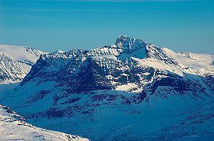
Såtbakkollen is a 1,632-metre (5,354 ft) tall mountain in Sunndal Municipality in Møre og Romsdal county, Norway. It is located in the Trollheimen mountain range, just north of the Sunndalen valley. It forms the southern end of the "Tårn massif", which also includes Tåga, Tårnfjellet, and the quite famous Innerdalstårnet. Other mountains nearby include Navardalsnebba, Trolla, and Skarfjellet.
Map of S%C3%A5tbakkollen, 6612 Gr%C3%B8a, Norway
The name "Såtbakkollen" is also commonly used for the peak Tåga (elevation: 1,840 metres or 6,040 feet, prominence: 950 metres or 3,120 feet; second highest point in Trollheimen). Tåga is actually located about 2.5 kilometres (1.6 mi) further north, probably because the name "Tåga" was missing from older maps.
References
Såtbakkollen Wikipedia(Text) CC BY-SA