
Surface area 44 acres (18 ha) Area 18 ha Designated as world heritage site January 1970 | Basin countries United States Surface elevation 420 m Outflow location Delaware River | |
 | ||
Similar Worthington State Forest, Mount Tammany, Delaware Water Gap, Delaware Water Gap National, Dunnfield Creek Natural A | ||
Hike to sunfish pond appalachian trail
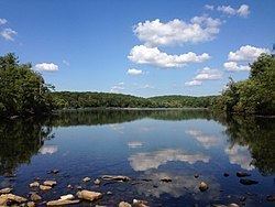
Sunfish Pond is a 44-acre (18 ha) glacial lake surrounded by a 258-acre (104 ha) hardwood forest located on the Kittatinny Ridge within Worthington State Forest, adjacent to the Delaware Water Gap National Recreation Area in Warren County, New Jersey. The Appalachian Trail runs alongside the western and northern edges of the lake. It was created by the Wisconsin Glacier during the last ice age. The lake was declared a National Natural Landmark in January 1970.
Contents
- Hike to sunfish pond appalachian trail
- Map of Sunfish Pond Hardwick NJ 07832 USA
- Gopro a hike to sunfish pond nj
- HistoryEdit
- Flora and faunaEdit
- VisitingEdit
- References
Map of Sunfish Pond, Hardwick, NJ 07832, USA
Gopro a hike to sunfish pond nj
HistoryEdit
The land was purchased by Charles C. Worthington who used the forest as a deer hunting preserve; the lake supplied water to his mansion.
In 1965, there was a plan to create a reservoir which would have covered the lake. Casey Kayes, a local custodian, led 655 people on a hike to protest the plan. Further hikes and letter campaigns caused the power companies that owned the land to donate it to the state in 1966. Supreme Court Justice William O. Douglas mentioned the lake in his dissenting opinion in the Sierra Club v. Morton case.
Flora and faunaEdit
The lake is surrounded by stands of mountain laurel, sheep laurel, and Cunila origanoides. Nearby are fields of Symphoricarpos orbiculatus. The lake itself also has Drosera rotundifolia growing near the edge.
VisitingEdit
It is a popular hiking destination. Several trails reach the lake, including the Appalachian Trail, which runs alongside the western and northern edges of the lake. It is the southernmost glacial tarn along that trail.
The shortest distance is 1.5 miles from the trailhead. The trails are steep and rocky in places. There is no swimming in the lake. There is a Leave No Trace campground about 1/4 mile away, but proper food precautions must be followed since black bears are active in the area.
There is a collection of ad hoc primitive rock artworks (cairns) along the northwestern shore. As of May 27, 2012, many of these piles of rocks have been pushed over.