
Surface area 13.24 km (5.11 sq mi) Area 13.24 km² | Surface elevation 355 m | |
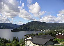 | ||
Strondafjorden (English: Stronda Fjord) is a lake which lies in the municipalities of Nord-Aurdal and Vestre Slidre in Oppland county, Norway. The lake is part of the Begna watershed. The northwest end of the lake is crossed by the Ulnes Bridge.
Map of Strondafjorden, Norway
It has an area of 13.24 km² and is 46.01 km around. It lies at an elevation of 355 m above sea level.
References
Strondafjorden Wikipedia(Text) CC BY-SA