
Time zone EET (UTC+2) Area code(s) +373 37 Area 730 km² | Postal Code 237 Car plates ST Population 91,500 (2012) | |
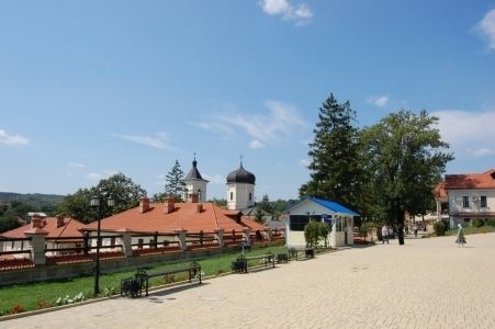 | ||
Strășeni is an administrative district (Moldovan: raion) in the central part of Moldova. Its administrative center and leading city is Strășeni. As of 1 January 2011, its population was 91,100. The other principal town is Bucovăț, 26 km (16 mi) to the north of the Moldovan capital. Otherwise the district is divided between rural communities.
Contents
- Map of StrC483C899eni District Moldova
- Toponymics
- History
- Geography
- Climate
- Fauna
- Flora
- Rivers
- Administrative subdivisions
- Demographics
- Religion
- Economy
- Education
- Politics
- Culture
- Health
- Transportation
- References
Map of Str%C4%83%C8%99eni District, Moldova
Toponymics
Strășeni is a toponym, of origin polysemantic as legends show in time, the name derived from the word "horrible" (in Romanian "strașnic") and the echo of these events materialize. In name of a hamlet of the forest Codri. Or in another version, outlaws hope nobleman, who travels on the road to Chișinău (19th century), so places were Scary. Another treatment of the toponym, as the traditional occupations linked to the natives. The parties were of Strășeni craftsmen, carpenters, just like a great eaves (in Romanian stresina).
History
The present territory of the district is inhabited since the stone age, 30-20.000 BC. Localities with the oldest historical attestation are Căpriana, Dolna, Lozova and Vorniceni, they are first attested in 1420. Căpriana monastery in 1429 received the status of the monastery. The present territory of the district Straseni, was part of the medieval lands Lăpușna County and Orhei County boundary of which is on the Bîc River. In 1545 is remembered by scribes, Strășeni district center. In the 16th-18th centuries, the district develop both economic (trade, agriculture, forestry) and cultural (built monasteries and churches), as there has been a major increase of population. In 1812, after the Russo-Turkish War (1806-1812), is the occupation of Basarabia, Russian Empire during this period (1812-1917), there is an intense russification of the native population. In 1918 after the collapse of the Russian Empire, Bessarabia united with Romania in this period (1918-1940, 1941-1944), the district is part of the Chișinău County. In 1940 after Molotov-Ribbentrop Treaty, Basarabia is occupied by the USSR. In 1991 as a result of the proclamation of Independence of Moldova, part and residence of the Chișinău County (1991-2003), and in 2003 became administrative unit of Moldova.
Geography
Strășeni district is located in the central part of Republic of Moldova. The neighboring district's are Călăraşi District in north-west, Orhei District in north-east, Criuleni District in east, municipality of Chișinău, Ialoveni District and Hînceşti District in south and Nisporeni in west. District is located on the Central Moldavian Plateau, and Codri forest region. Relief hilly terrain sloping from northwest to southeast, cut by valleys and rivers. Erosion processes with a high intensity. The soil is mainly brown soil forest and gray soil.
Climate
Temperate continental climate, annual average temperature +10 C. The average temperature in July +22 c, in January from -4-5 C. The annual precipitation 550–650 mm. Average wind speed 3–6 m s.
Fauna
Fauna typical central Europe, with the presence of such mammals such as fox, wild boar, deer, hedgehogs, wild cat, red deer, wolf, raccoon dog, wild cat, ferret and others. Of birds: hawk, crow, stork, eagles, egrets and more. In the past forests were populated district of: brown bear, elk, bull, wisent, disappeared due to excessive hunting, but the deforestation.
Flora
Forests occupy 36.6% of the district are characterized by the presence of oak, english oak, beech, hornbeam, maple, ash, lime and other trees. From plants: clover, bell, nettle and others.
Rivers
District is located in the Nistru river basin. The main tributaries that cross the district are: Ichel (102 km) and Bic (152 km). Most lakes have a natural origin. The largest is Ghidighici Reservoir.
Administrative subdivisions
Demographics
1 January 2012 the district population was 91,500 of which 23.7% urban and 76.3% rural population
Religion
Economy
Main branches of the economy are agriculture and manufacturing in district. Soil and climatic conditions favor the growth of cereals, sunflower, grapes, vegetables, fruit and other crops. Of mineral resources in the district is stone, gravel, pebbles and sand of building in Micauti career. Communication services are provided in Straseni two companies "Moldtelecom" and "Post of Moldova". The territory they are operating 15 factories processing of grapes, a poultry factory in Bucovăţ. Industry district is represented by 17 companies. The largest factory: SA "Marsrut", JSC "Caan" experimental-mechanical plant (included in the national privatization program.
Arable land occupies 18 903 ha (25.9%) of the total agricultural land, vineyards occupy 8292 ha (11.3%), plantations of orchards 3.386 ha (4.6%), 3244 ha grassland (4.4%), 242 ha plantation of fruit trees (0.3%), some 451 ha (0.6%).
Education
In district active: 42 educational institutions, including: Total number of students: 10,721. Currently the educational institutions of district teacher's operate in 1040.
Politics
Straseni district, both political and electoral support of right-wing parties in Moldova represented by the AEI. PCRM is in a continuous fall in the last three elections.
During the last three elections AEI had an increase of 73.0%
Culture
In Straseni works: 72 cultural institutions, a culture house, 32 community centers, clubs, 35 libraries, two art schools, three museums and a famous monastic complex.
Health
In Straseni district works: a hospital with general fund of 192 beds, a center of family physicians in the composition of which are 15 offices of family doctors, 13 health centers, 9 offices of health, the health district population. District operates: 134 doctors, 297 personal care environment, medical and auxiliary personnel 306.
Transportation
All localities have regular routes to regional centers and capital. The district is crossed by railways, means of communication used extensively to transport goods by business district, and especially the town Straseni. District is crossed by the M1 road highway (Chisinau-Ungheni).