
Elevation 2,850 m | Prominence 253 m | |
 | ||
Similar Mount Cleveland, Mount Merritt, Cathedral Peak, Pyramid Peak, Chief Mountain | ||
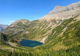
Stoney Indian Peaks (9,350 feet (2,850 m)) is located in the Lewis Range, Glacier National Park in the U.S. state of Montana. Consisting of several summits, the mountain is in the northeastern region of Glacier National Park, less than 2 miles (3.2 km) south of Mount Cleveland. Stoney Indian Lake is south of the peaks.
Map of Stoney Indian Peaks, Montana 59417, USA
References
Stoney Indian Peaks Wikipedia(Text) CC BY-SA