
First ascent 1892 Parent range Lewis Range | Elevation 2,768 m Prominence 561 m Easiest route Climbing | |
 | ||
Similar Mount Cleveland, Mount Siyeh, Going‑to‑the‑Sun Mountain, Mount Gould, Mount Wilbur | ||
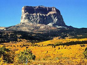
Chief Mountain (also called Old Chief Mountain) is located in the U.S. state of Montana on the eastern border of Glacier National Park and the Blackfeet Indian Reservation. The mountain is one of the most prominent peaks and rock formations along the Rocky Mountain Front, a 200 mi (320 km) long overthrust fault, known as the Lewis Overthrust, which extends from central Montana into southern Alberta, Canada.
Contents
- Map of Chief Mountain Montana 59417 USA
- The peakEdit
- Many names for a sacred placeEdit
- ClimbingEdit
- References
Map of Chief Mountain, Montana 59417, USA
The peakEdit
The peak is easily seen from Montana and Alberta due to the rapid 5,000 foot (1,524 m) altitude gain over the Great Plains which are immediately east of the mountain. Despite the mountain's being mostly in Montana, the distinctive eastern face quickly becomes hidden as one travels south into Montana, but remains very easy to see on clear days over much of southern Alberta. Hence, many businesses in the area (notably Lethbridge) have "Chief Mountain" in their name. Chief Mountain is one of the most photographed mountains in the region due to its unique nature.
Chief Mountain is an example of a klippe. It consists of a Precambrian block which rests directly above much younger Cretaceous gray shales. Having an older layer (Precambrian in this case) pushed up to the top is typical of thrust faults. The surrounding portion of the thrust sheet has been removed by erosion leaving behind this isolated block of Proterozoic rock.
Many names for a sacred placeEdit
Chief Mountain has been a sacred mountain to Native American tribes for hundreds of years. The Blackfoot name for the mountain is Nínaiistáko. The mountain was seen by white explorers in the late 18th century and was known as "Kings Peak" on maps produced in the United Kingdom in 1795. Meriwether Lewis, co-leader of the Lewis and Clark Expedition, saw the mountain in 1805 and called it "Tower Mountain". The name was changed in the late 19th century in reflection of Blackfeet naming of the mountain which was "Great Chief". When Glacier National Park was created in 1910, the summit and most prominent eastern slopes of the mountain were located within the park, leaving only the lower slopes within Blackfeet jurisdiction. The northwestern enemy of the Blackfoot, the Nakoda (Stoney), called it also Hũga Baha (″Chief Hill″).
Chief Mountain remains sacred to many First Nations peoples from both the US and Canada. Natives from all over North America travel to the base of the mountain for sweet grass ceremonies, placing of prayer flags and other religious rites. In the early 1900s as white settlers came to the area, they observed native burial sites scattered along the base of the mountain. Elders from Southern Alberta's Siksika Band (where the Great Chief Crowfoot hailed from) and other First Nation groups have an oral tradition that near the end of days, a Great White God would appear from the top of Chief Mountain and upon his departure, the mountain would crumble and be destroyed.
ClimbingEdit
The eastern face of the mountain rises over 1,500 vertical feet (457 m) and the easiest route on this section is rated class 4 by mountaineers. The rock is also primarily sedimentary and provides poor anchor points, which in turn is a contributing factor to the difficulty rating. Henry Stimson and two other explorers, including a Blackfeet Indian, climbed the difficult eastern face on September 8, 1892, and this is the first known ascent of the peak by white explorers. Upon the summit, Stimson's party observed ceremonial remains including bison skulls that had been left behind by Native Americans. The eastern face of the peak wasn't successfully climbed again until 1951. Though the summit can be gained by approaching from the west, the easiest access is from the east, and the Blackfeet tribe may issue access permits to cross reservation lands. This entire area is sacred to the Blackfeet and utmost respect should be shown. National Park Service visitor centers at St. Mary, Montana and at Many Glacier have additional information available.