
Elevation 536 m | Topo map OS Landranger 137 Prominence 357 m Listing Marilyn | |
 | ||
Similar Corndon Hill, Caer Caradoc, Brown Clee Hill, Haughmond Hill, Heath Mynd | ||
Walking stiperstones shropshire walks in england uk
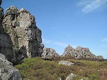
The Stiperstones is a distinctive hill in the county of Shropshire, England. It is a quartzite ridge formed some 480 million years ago. During the last Ice Age the summit stood out above the glaciers and was subject to constant freezing and thawing which shattered the quartzite into a mass of jumbled scree surrounding several residual rocky tors. At 536 metres (1,759 ft) above sea level it is the second-highest hill in the county, surpassed only by Brown Clee Hill (540 metres (1,772 ft)). Stiperstones' 8-kilometre (5 mi) summit ridge is crowned by several rugged, jagged outcrops of rock silhouetted against the sky.
Contents
- Walking stiperstones shropshire walks in england uk
- Map of Stiperstones Shrewsbury UK
- Stiperstones shropshire hills
- GeographyEdit
- Wildlife and conservationEdit
- Bog Mine and Visitor CentreEdit
- 2012 fireEdit
- References
Map of Stiperstones, Shrewsbury, UK
Stiperstones shropshire hills
GeographyEdit
The Stiperstones is noted for its tors of quartzite. The principal ones are named as follows, from north-east to south-west:
Manstone Rock is the highest of these at 536 metres (1,759 ft), and is topped with a trig point. The Devil's Chair is the largest and best known.
The Stiperstones ridge is a good place to view the upland landscape of the Shropshire Hills, particularly the Long Mynd to the east, and also gives extensive views towards the North Shropshire plain and the hills of Mid Wales.
Wildlife and conservationEdit
The Stiperstones is a National Nature Reserve and Site of Special Scientific Interest (SSSI). and is within the Shropshire Hills Area of Outstanding Natural Beauty. It is a haven for wildlife, with birds that are normally associated with upland areas present, including red grouse, Eurasian curlew, peregrine falcon and the rare ring ouzel.
Recently, a project called Back to Purple has commenced, to clear some of the hill of remaining plantations of coniferous and wooded areas, restoring the land to heather-based heath, with seasonal purple-flowering heather covering the summits around the tors and enhancing the views of the Stiperstones from the surrounding peaks and valleys. Back to Purple is managed by a partnership of Natural England, Forest Enterprise and the Shropshire Wildlife Trust. Their work has so far seen removal of thousands of pine trees and conifers, including the whole Gatten Plantation (still shown on OS maps) and the previously covered Nipstone Rock has emerged from hiding. Thousands of heather seedlings have been successfully planted to supplement natural regeneration. To balance this out and complement it further work below summit level has also aimed at restoring grasslands, rich in herbs, hay meadows, wet flushes which produce bog cotton, Heath Bedstraw and the rarer Mountain Pansy and natural woodlands.
Bog Mine and Visitor CentreEdit
Until the early 20th century lead was mined at The Bog, just west of Stiperstones. The mine at The Bog and the adjacent Stiperstones outcrop were only viable because of a geological movement; over time the movement of the tectonic plates landed at this site, combined with the movement of the earth it crumpled the layers and the softest layers were then eroded away. After mining stopped, the undisturbed remnants provided a range of wildlife habitats: birds nest in the old buildings, bats roost in the old mine tunnels, and reservoirs and ponds are ideal for aquatic life.
The Bog Visitor Centre is the main facility for visitors to the Stiperstones. It is housed in the former village school and retains its old interior design. It provides historical information about the past workers, mining, and present-day work to restore the landscape. Facilities at the centre include toilets and car parking (with facilities for the disabled including reserved parking, toilets and ramps). Activities include walking, with two main circular walks called Mucklewick Walk and Flenny Bank Walk and a variety of riding routes.
2012 fireEdit
On 25 July 2012 part of the reserve was devastated by fire, said to have been a result of the sudden upturn in dry, hot weather coupled with the large amount of dry heather on the hills. More than 70 firemen battled the fire between 15.00 and 22.00 BST; smoke could be seen up to 10 miles away in the county town of Shrewsbury. Firefighters remained on site throughout the night because of the severity of the fire and the extent of the affected areas.