
OS grid SO306969 Elevation 513 m | Topo map OS Landranger 137 Prominence 201 m Listing Marilyn | |
 | ||
Similar Stiperstones, Caer Caradoc, Heath Mynd, Brown Clee Hill, Long Mountain | ||
see also: Hyssington
Map of Corndon Hill, Shrewsbury, UK
Corndon Hill is a hill in Powys, Mid Wales, whose summit rises to 1,683 ft above sea level.
It is surrounded on three sides by the English county of Shropshire and forms a prominent landmark in the Wales-England border. Corndon's prominent western edge appears to form a separate hill and is known locally as Lan Fawr (Welsh: 'Big Hill').
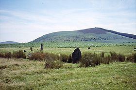
The Bronze Age stone circles of Mitchell's Fold and the now largely destroyed The Whetstones lie at the foot of the hill within Shropshire.
Corndon Hill is often used as a launch site by paraglider pilots, usually in an easterly wind.
References
Corndon Hill Wikipedia(Text) CC BY-SA