Criteria ii, iv, v UNESCO World Heritage Site inscription 1996 | Type Cultural Reference 759 | |
 | ||
UNESCO region Europe and North America Similar Fort bij IJmuiden, Pampus, Fort bij Spijkerboor, Fort Vijfhuizen, Fort bij Uitermeer | ||
Librarylook stelling van amsterdam amsterdam defence line
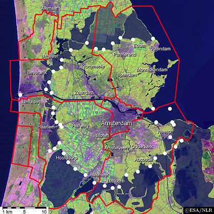
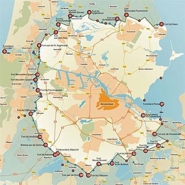
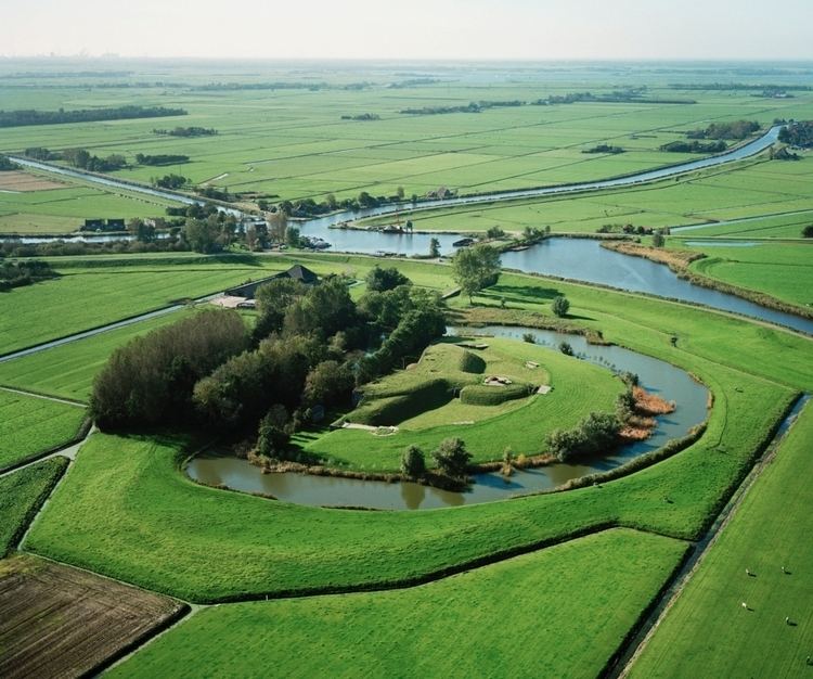
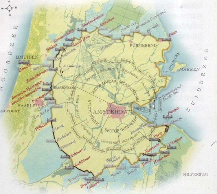
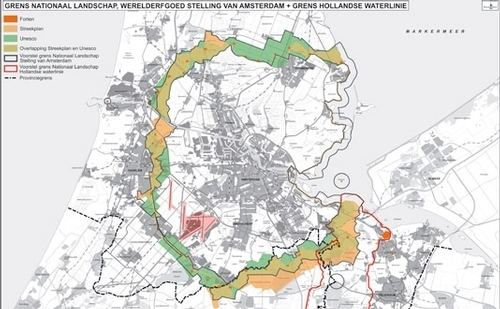
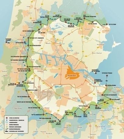
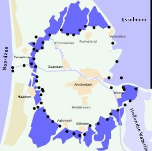
The UNESCO World Heritage Site known as the Defence Line of Amsterdam (in Dutch named Stelling van Amsterdam) is a 135 km long ring of fortifications around Amsterdam, consisting of 42 forts located between 10 and 15 kilometers from the centre, and lowlands that can easily be flooded in time of war. The flooding was designed to give a depth of about 30 cm, insufficient for boats to traverse. Any buildings within 1 km of the line had to be made of wood, so that they could be burnt and the obstruction removed.
Contents
- Librarylook stelling van amsterdam amsterdam defence line
- Function
- Construction
- Service
- North front
- Northwest front
- West front
- Southwest front
- South front
- Southeast front
- Zuiderzee front
- References
The Stelling van Amsterdam was constructed between 1880 and 1920. The invention of the aeroplane and tank made the forts obsolete almost as soon as they were finished. Many of the forts now are under both the control of the town councils and the nature department and may be visited. Monuments Day, on the second Saturday in September, is the ideal day to visit, as entrance is free.
Function
The Stelling van Amsterdam was primarily a defensive "water line" (in Dutch: waterlinie). In the event of an enemy attack, large tracts of land around Amsterdam would be inundated with water, preventing the enemy from advancing. Amsterdam would function as a national redoubt or reduit, as the last stronghold of the Netherlands. Forts were built where roads, railways, or dikes crossed through the water line. At such locations there would be no water to stop the enemy, and therefore the forts were intended to shell the enemy.
Construction
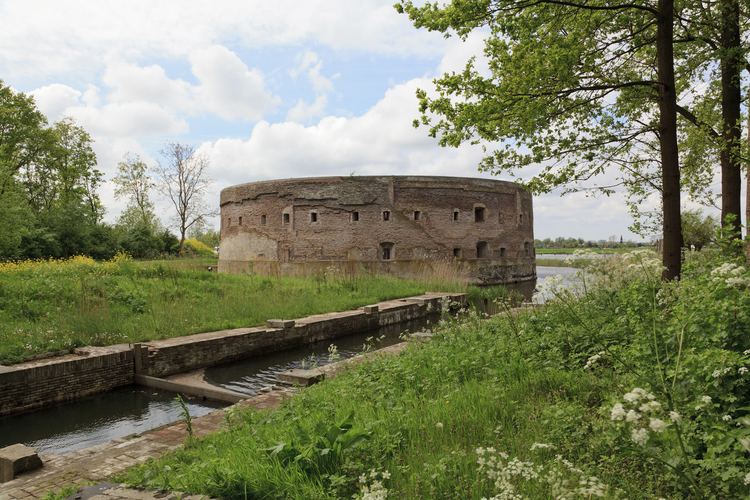
The law for the construction of the Stelling van Amsterdam was passed in 1874 - a few years after the Unification of Germany which placed a powerful new Great Power on the Netherlands' eastern border. During the preparations prior to construction, it became apparent that the design was already outdated by modern technical advances. The invention of the brisance grenade (which would explode on impact of the target) necessitated the change from masonry to concrete forts. The Dutch did not have the required experience yet using and building with concrete so extensive tests had to be performed; concrete structures were shelled with the heaviest artillery available at that time. Further delays resulted from the fact that the sand foundations had to settle for several years before the forts could be built on them. Only in 1897 could the actual construction finally begin.
Service
The Stelling van Amsterdam has never seen combat service and the use of aircraft rendered it obsolete after World War I. It was however maintained and kept in service until it was decommissioned in 1963.
The dike through the Haarlemmermeer, which made it possible to flood the southern portion of the polder while the northern portion could continue to produce food for Amsterdam, is now cut by the A4 Motorway. This motorway also goes under the Ringvaart at Roelofarendsveen, making flooding of the Haarlemmermeer Polder, and future use of the Stelling no longer possible.
In 1996, the complete Stelling van Amsterdam was designated as a UNESCO World Heritage Site.
North front
Northwest front