
Population 1,371 (2011 census) Sovereign state United Kingdom Area 2.63 km² Dialling code 01753 | OS grid reference TQ0374 Local time Sunday 2:22 AM UK parliament constituency Spelthorne | |
 | ||
Weather 6°C, Wind NE at 16 km/h, 52% Humidity | ||
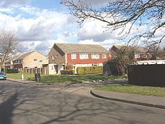
Stanwell Moor is a rural and suburban clustered settlement, informally known as a village, in Surrey, England, immediately east of the M25 London Orbital Motorway, south-west of Heathrow airport and west of the village of Stanwell. It has a separate community hall and residents' organisation.
Contents
- Map of Stanwell Moor Staines UK
- History and geography
- Local government
- Amenities
- Demography and housing
- References
Map of Stanwell Moor, Staines, UK
Distributaries of the complex River Colne run past Stanwell Moor where it forms a broad part of the Colne Valley regional park. Stanwell Moor is buffered from all other settlements. Its south is covered by the King George VI Reservoir after which is Staines upon Thames. South-west is the Wraysbury Reservoir.
History and geography
The locality gained its main barrier from what had always been its village in the early 1960s, a dual carriageway and it hived off shortly after with the building of a community hall and establishment of its own residents' association. It is however, ecclesiastically, still strongly tied with Stanwell in the Church of England, its parish. Fewer than six of the original medieval buildings stand in the hamlet.
It sits on the part of the parish on strongly fertile, partly densely wooded, alluvial soil, whereas most of Stanwell was associated with the stony ground which makes up gravel deposits near to the surface of the soil, as throughout the area south of Heathrow Airport to the River Thames.
Local government
The community is in the Stanwell North ward, as used by Spelthorne and for certain statistical purposes. Stanwell Moor is represented by Labour's Robert Evans, on Surrey County Council.
Amenities
A parade of shops is here, followed at one end by a pub. A further pub is by the Colne itself. Distributaries of the complex River Colne runs past Stanwell Moor where it forms a broad part of the Colne Valley regional park. Stanwell Moor is buffered from all other settlements. Its south is covered by the King George VI Reservoir after which is Staines upon Thames. South-west is the Wraysbury Reservoir.
Demography and housing
The average level of accommodation in the region composed of detached houses was 28%, the average that was apartments was 22.6%.
The proportion of households in the settlement who owned their home outright compares to the regional average of 35.1%. The proportion who owned their home with a loan compares to the regional average of 32.5%. The remaining % is made up of rented dwellings (plus a negligible % of households living rent-free).