
Basin countries United Kingdom | Area 205 ha | |
 | ||
Surface area 2.05 square kilometres (0.79 sq mi) Water volume 34 Gl (7.5×10^ imp gal) Similar King George VI Reservoir, Staines Reservoirs, Queen Mary Reservoir, Stanwell Place, St Mary's - Staines | ||
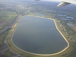
The Wraysbury Reservoir is a water supply reservoir for London, just west of the M25 near the village of Wraysbury, and directly under the western approach path of London Heathrow airport. The reservoir was begun in 1967 and completed by W. & C. French in 1970 with a capacity of 34,000 million litres.
Map of Wraysbury Reservoir, Stanwell, Staines, UK
The reservoir is owned and operated by Thames Water; 400 million litres of water are pumped daily from an inlet at Datchet on the River Thames. A neighbouring reservoir is the King George VI Reservoir, opened in 1947, which is supplied from Hythe End. To keep the grass short and make inspections easier, Thames Water maintains a flock of sheep on the earthen banks.
Wraysbury Reservoir has an area of 2.05 square kilometres (0.79 sq mi) excluding its embankment. It has been designated since 1999 as a Site of Special Scientific Interest. Its citation reads:
[It] regularly supports nationally important numbers of wintering cormorant Phalacrocorax carbo, great crested grebe Podiceps cristatus and shoveler Anas clypeata...[It] is an artificially embanked reservoir constructed around 1970. The reservoir also support [sic] notable numbers of wintering gadwall Anas strepera.
The SSSI is close to another in Berkshire resulting from gravel extractions at Wraysbury.