
Country United States FIPS code 27-57130 Elevation 334 m Population 6,656 (2013) | Time zone Central (CST) (UTC-6) GNIS feature ID 0650746 Area 10.08 km² Local time Friday 5:42 PM | |
 | ||
Weather 3°C, Wind N at 14 km/h, 81% Humidity Colleges and Universities College of Saint Benedict and Saint John's University, College of Saint Benedict | ||
St. Joseph is a city in Stearns County, Minnesota, United States. The population was 6,534 at the 2010 census and according to 2015 census estimates is now 6,864. It is home to the College of Saint Benedict.
Contents
Map of St Joseph, MN, USA
St. Joseph is part of the St. Cloud Metropolitan Statistical Area.
History
St. Joseph was laid out in 1855, and named after a local church. St. Joseph was incorporated in 1890.
Geography
According to the United States Census Bureau, the city has a total area of 3.89 square miles (10.08 km2), all of it land.
Stearns County Road 75 serves as a main route in the community. Other routes include County Roads 2, 3, 121, 133, and 134. Interstate 94 is nearby.
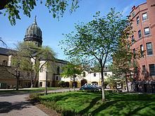
Some of the city's major landmarks include St. Joseph Catholic Church, St. Benedict's Monastery, and The College of St. Benedict. The College of Saint Benedict is an all-women's Catholic college, and the complex is noted in the downtown area for the high spire of St. Joseph's Church, and the rotunda and dome of the Monastery and College Sacred Heart Chapel. The architecture is different from other buildings and the major structures are visible from miles away.
2012 census
The population in 2012 was 6,656 people with 99% being urban and 1% rural. 2,004 are males making up for 30.1% and 4,652 are females making up 69.9% of the population. The racial makeup of the city was 94.9% white alone, 1.7% Asian, 1.5% Hispanic, 1.2% African American, and 0.3% American Indian. The average age of residents is 22.7 years old. The estimated median household income was $58,644 while the estimated per capita income was $19,723. House or condo values were estimated to be about $157,404.
2010 census
As of the census of 2010, there were 6,534 people, 1,845 households, and 1,184 families residing in the city. The population density was 1,679.7 inhabitants per square mile (648.5/km2). There were 1,912 housing units at an average density of 491.5 per square mile (189.8/km2). The racial makeup of the city was 93.7% White, 1.1% African American, 0.2% Native American, 2.4% Asian, 0.9% from other races, and 1.7% from two or more races. Hispanic or Latino of any race were 1.9% of the population.
There were 1,845 households of which 33.3% had children under the age of 18 living with them, 50.7% were married couples living together, 9.5% had a female householder with no husband present, 4.0% had a male householder with no wife present, and 35.8% were non-families. 21.2% of all households were made up of individuals and 5.3% had someone living alone who was 65 years of age or older. The average household size was 2.61 and the average family size was 2.96.
The median age in the city was 22.7 years. 17.1% of residents were under the age of 18; 37.7% were between the ages of 18 and 24; 22.3% were from 25 to 44; 15.1% were from 45 to 64; and 7.9% were 65 years of age or older. The gender makeup of the city was 37.2% male and 62.8% female.
2000 census
As of the census of 2000, there were 4,681 people, 1,120 households, and 712 families residing in the city. The population density was 2,517.4 people per square mile (971.7/km²). There were 1,147 housing units at an average density of 616.8 per square mile (238.1/km²). The racial makeup of the city was 96.69% White, 1.00% African American, 0.21% Native American, 0.98% Asian, 0.06% Pacific Islander, 0.38% from other races, and 0.66% from two or more races. Hispanics or Latinos of any race were 1.22% of the population.
There were 1,120 households out of which 35.5% had children under the age of 18 living with them, 48.2% were married couples living together, 10.9% had a female householder with no husband present, and 36.4% were non-families. 21.3% of all households were made up of individuals and 6.1% had someone living alone who was 65 years of age or older. The average household size was 2.74 and the average family size was 3.06.
The age distribution is 16.7% under the age of 18, 44.4% from 18 to 24, 19.8% from 25 to 44, 10.4% from 45 to 64, and 8.6% who were 65 years of age or older. The median age was 22 years. For every 100 females there were 46.4 males. For every 100 females age 18 and over, there were 39.1 males.
The median income for a household in the city was $38,938, and the median income for a family was $44,737. Males had a median income of $33,344 versus $22,007 for females. The per capita income for the city was $12,011. About 5.4% of families and 20.8% of the population were below the poverty line, including 7.7% of those under age 18 and 35.2% of those age 65 or over.