
OS grid reference TM458994 Postcode district NR31 | Sovereign state United Kingdom Local time Friday 10:30 AM | |
 | ||
Weather 16°C, Wind SW at 18 km/h, 70% Humidity | ||
St Olaves is a village in the English county of Norfolk. The village is situated on the River Waveney in England, some 10 kilometres (6 mi) south-west of the town of Great Yarmouth and the same distance north-west of the Suffolk town of Lowestoft. It is within The Broads National Park.
Map of St Olaves, Great Yarmouth, UK
Today the village forms part of the civil parish of Fritton and St Olaves , which in turn is within the district of Great Yarmouth in Norfolk. However prior to the Local Government Act 1972, the village was within Lothingland Rural District in Suffolk.
St Olaves Bridge, a suspension bridge, is the first bridging point on the Waveney above Great Yarmouth. Haddiscoe railway station, on the Wherry Lines service between Norwich and Lowestoft, is across the bridge approximately 1 kilometre (1 mi) from the centre of the village. St Olaves used to have its own St Olaves railway station, but this is now closed.
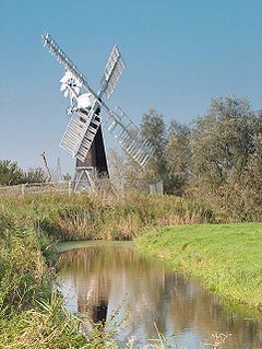
On the site of the priory dedicated to St Olaves, there is Priory Mill, a drainage windpump.