
Country India Area 2,615 km² Literacy 69% Area code 01633 | Talukas Sri Muktsar Sahib Elevation 184 m Population 902,702 (2011) | |
 | ||
Colleges and Universities Guru Teg Bahadur College of Engineering & Technology, Guru Nanak College | ||
Sri Muktsar Sahib district (Punjabi: ਸ੍ਰੀ ਮੁਕਤਸਰ ਸਾਹਿਬ ਜ਼ਿਲ੍ਹਾ) is one of the twenty two districts in the Indian Punjab and earlier known as khidraane di dhaab. Its capital, the city of Sri Muktsar Sahib, is renamed from Muktsar to Sri Muktsar Sahib and so the district. Other towns include Malout (the largest town by population) and Giddarbaha.
Contents
Map of Sri Muktsar Sahib, Punjab
History
Muktsar district was created as a new district on 7 November 1995 by taking out Muktsar subdivision of Faridkot district.
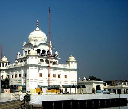
The last battlefield of the tenth Sikh Guru, Shri Guru Gobind Singh, lies in the district's main city. A huge battle, knowns as Battle of Muktsar, took place between the Mughals and the Sikhs in 1705 where a Gurudwara, Gurudwara Tibbi Sahib, now marks the site.
The district has many historical Gurudwaras including, Darbar Sahib, Shaheedi Gurudwara, and Tibbi Sahib in the main city and many more in the different villages of the district.
A huge fair, known as "Mela Maghi", is celebrated in January every year at Sri Muktsar Sahib city in the memory of the forty martyrs (librated ones).
Demographics
According to the 2011 census Sri Muktsar Sahib district has a total population of 902,702, roughly equal to the nation of Fiji or the US state of Delaware. This gives it a ranking of 464th in India (out of a total of 640). The district has a population density of 348 inhabitants per square kilometre (900/sq mi). Its population growth rate over the decade 2001-2011 was 16.1%. It has a sex ratio of 895 females for every 1000 males and a literacy rate of 66.8%.
The principal Jatt Sikh clans are, Sidhu Brar, Sandhu, Sekhon, Buttar, Gill, Maan, Bhullar, Aulakh, Virk, Dhaliwal, Dhillon.