
Topo map USGS Split Mountain Elevation 4,287 m Mountain range Sierra Nevada Parent range Sierra Nevada | Prominence 465 m | |
 | ||
First ascent 1887, Frank Saulque and party Easiest route North slope, scramble (class 2) Similar Middle Palisade, North Palisade, Mount Sill, Mount Tyndall, Mount Langley | ||
Split Mountain is a fourteener in the Sierra Nevada of the U.S. state of California, near the southeast end of the Palisades group of peaks. It is the only fourteener in the watershed of the South Fork Kings River, and rises to 14,064 ft (4,287 m), making it the eighth-highest peak in the state.
Contents
- Map of Split Mountain California 93513 USA
- Geography and GeologyEdit
- HistoryEdit
- ClimbingEdit
- References
Map of Split Mountain, California 93513, USA
Geography and GeologyEdit
Split Mountain's twin summits lie on a north-south running section of the Sierra crest. This same line of ridges divides Fresno County and Kings Canyon National Park to the west, from Inyo County and the Inyo National Forest to the east. The water divide of its ridges drain to the Kings River to the west, and the Owens River to the east.
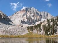
The two toned appearance of the mountain's eastern face is created by a roof pendant of darker colored granodiorite atop a lighter colored body of leucogranite.
HistoryEdit
The name Split Mountain, inspired by the shape of its double summit, was first coined by mountaineer Bolton Brown in 1895. Alternately, it has been called Southeast Palisade or South Palisade.
ClimbingEdit
Split Mountain is one of the easier California fourteeners to climb. The least technical route is the class 2 north slope, which can be approached from the west or east. Joseph LeConte, Helen LeConte and Curtis Lindley took the simple western approach from Upper Basin when they climbed Split Mountain on July 23, 1902. A more common route to the north face is from the east, by way of Red Lake. Starting at the Red Lake trailhead, this trail covers 6 miles (10 km) with 4,000 feet (1,220 m) of elevation gain one way to the lake. From here, another 3,500 ft (1,070 m) of cross-country climbing, including a short class 3 ridge traverse, leads to the summit.
There are many more technical routes up both the north and south peaks of Split Mountain.