
First ascent 24 July 1903 Mountain range Sierra Nevada Parent range Sierra Nevada | Elevation 4,314 m Prominence 108 m | |
 | ||
Listing California fourteeners 6thSPS Mountaineers peakWestern States Climbers Star peak Easiest route Glacier climb & rock scramble Similar North Palisade, Middle Palisade, Thunderbolt Peak, Split Mountain, Norman Clyde Peak | ||
8 mount sill 14 153 sierra bivys oct 4 sunrise 2013 dr jon kedrowski
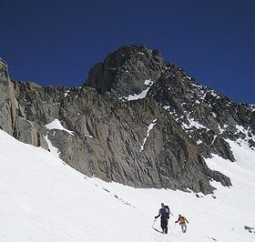
Mount Sill is one of the fourteeners of the Sierra Nevada in California. It is located in the Palisades, a group of striking rock peaks with a few small glaciers on their flanks. Mount Sill is located 0.6 miles (1 km) east of North Palisade, the high point of the group. The two peaks are connected by a high, rocky ridge, on the north side of which lies the Palisade Glacier. Mount Sill lies on the main Sierra Crest, but is at a point where the crest turns sharply, giving it particularly striking summit views. On one side is Kings Canyon National Park and Fresno County; on the other is the John Muir Wilderness, Inyo National Forest and Inyo County.
Contents
- 8 mount sill 14 153 sierra bivys oct 4 sunrise 2013 dr jon kedrowski
- Map of Mt Sill California USA
- References
Map of Mt Sill, California, USA
Routes on Mount Sill are found on all sides of the peak and range in difficulty from scrambles (class 2-3) to a moderately technical rock climbs (class 5.7).
The mountain is called Nen-i-mish ("the Guardian of the Valley") by the indigenous Northern Paiute people. Its English name was coined, in 1904, by Joseph LeConte, a noted mountaineer, in honor of American poet Edward Rowland Sill.