
 | ||
Numerous special routes of U.S. Route 67, all business routes, exist. One other route, formerly an alternate route in western Illinois, has since been downgraded to state Route 267.
Contents
- Texas
- Presidio business loop
- Major intersections
- San Angelo business loop west
- San Angelo business loop east
- Dublin business loop
- Cleburne business loop
- Alvarado business loop
- Sulphur Springs business loop
- Midlothian business loop
- Greenville business spur
- Beebe business route
- Searcy business route
- Walnut RidgeHoxie business route
- Biggers business route
- Datto business route
- Historic route in Illinois
- References
Texas
All of the business routes within Texas are maintained by the Texas Department of Transportation (TxDOT). U.S. Route 67 has seven current and two former business routes within the state, with two of these located in San Angelo. Along US 67, TxDOT identifies each business route as Business U.S. Highway 67 followed by an alphabetic suffix. Along Texas U.S. routes, the alphabetic suffixes on business route names ascend generally eastward and southward. As US 67 is labeled as a west-to-east route, its initial business loop in Presidio is suffixed with an A. There are gaps in the alphabetic values to allow for future system expansion or for decommissioned routes. The alphabetic naming suffixes are included as small letters on the bottom of route shields.
Presidio business loop
Business U.S. Highway 67-A or Bus. US 67-A is a business loop of US 67 at Presidio in Presidio County commissioned in 1996. The 1.8-mile (2.9 km) route begins at US 67 west of town near the Presidio-Ojinaga International Bridge and proceeds along O'Reilly St. to Farm to Market Road 170. The route then turns north along Erma St. to State Spur 203. The route then turns west and rejoins US 67 north of town.
Much of the route, along with SS 203, was the former route of US 67 through town before the present US 67 was constructed to bypass the town to the northwest in 1996.
Major intersections
The entire route is in Presidio County.
San Angelo business loop (west)
Business U.S. Highway 67-H or Bus. US 67-H is a business loop of US 67 at San Angelo in Tom Green County commissioned in 1996. The certified mileage of the 5.0-mile (8.0 km) route, one of two business loops within San Angelo, does not include portions concurrent with US 87 and US 277. From US 67 and State Highway Loop 306 west of town, the route follows Sherwood Way and Beauregard Ave. eastward to US 87 and US 277. The route then overlays US 87 and US 277 along Abe St. (southbound) and Koenigheim Dr. (northbound) to US 67.
The portion of the business loop over Sherwood Way and Beauregard Ave. was part of the former route of US 67 before the completion of the Houston Harte Expressway in 1984. Between 1984 and 1996, this portion was designated as part of Loop 545.
Major intersections
The entire route is in Tom Green County.
San Angelo business loop (east)
Business U.S. Highway 67-J or Bus. US 67-J is a business loop of US 67 at San Angelo in Tom Green County commissioned in 1996. The certified mileage of the 3.7-mile (6.0 km) route, one of two business loops within San Angelo, does not include portions concurrent with Loop 306. From US 67 in central San Angelo, the route follows Main St. south to Pulliam St.. The route then follows Pulliam St. east to Loop 306 and then overlays Loop 306 north to US 67. The business loop also has major intersections with US 277 and FM 380.
The portion of the business loop over Pulliam St. west of Ball St. was part of the former route of US 67 before the completion of the Houston Harte Expressway in 1984. Between 1984 and 1986, the Main St. portion was designated as part of Loop 545.
Major intersections
The entire route is in Tom Green County.
Dublin business loop
Business U.S. Highway 67-K or Bus. US 67-K is a business loop of US 67 at Dublin in Erath County commissioned in 2001. The business loop was designated over a 4.6-mile (7.4 km) segment of the current US 67 and US 377 known locally as Patrick St. through Dublin in anticipation of future construction of a new alignment for US 67 and US 377 bypassing Dublin. The route so far maintains its designation even though the proposed bypass route was reassigned with a new designation as State Highway 267 in 2012. The route has major intersections with SH 6 and FM 219.
Major intersections
The entire route is in Erath County.
Cleburne business loop
Business U.S. Highway 67-M or Bus. US 67-M is a business route of US 67 at Cleburne and Keene in Johnson County commissioned in 1996. The 8.1-mile (13.0 km) route begins at US 67 west of Cleburne and follows along Henderson St. to central Cleburne. In central Cleburne between Walnut St. and Border St., the roadway divides onto two one-way streets one block from each other with northbound traffic circulating along Chambers St. while southbound traffic continues along Henderson St. Along this portion, the route intersects SH 171 and SH 174. The route then continues along Henderson St. through Cleburne and then enters Keene. The route intersects FM 2280 before terminating at US 67 and Spur 102.
The route follows the former route of US 67 before US 67 was relocated around Cleburne in 1996 replacing the former Loop 367.
Major intersections
The entire route is in Johnson County.
Alvarado business loop
Business U.S. Highway 67-N or Bus. US 67-N is a business route of US 67 at Alvarado in Johnson County commissioned in 1990. The 1.2-mile (1.9 km) route begins at Bus. I-35-V and follows College St. to FM 1706. The route then curves northward joining Baugh St. until it terminates at US 67.
The route follows part of the former location of US 67 through town before 1963. The route was designated Spur 379 from 1963 to 1990 although it was signed as Bus. US 67.
Major intersections
The entire route is in Johnson County.
Sulphur Springs business loop
Business U.S. Highway 67-V or Bus. US 67-V is a business route of US 67 at Sulphur Springs in Hopkins County commissioned in 1990. The certified mileage of the 6.6-mile (10.6 km) route does not include portions concurrent with SH 11 and SH 154. The route begins at Exit 120 of Interstate 30 and US 67 west of town and proceeds northeastward along Main St.. The route intersects SH 19 on Sulphur Springs' west side and continues along Main St. to Davis St. in central Sulphur Springs. From this point, the route follows College St. and then merges with SH 11 and SH 154 along two one-way streets with northbound traffic circulating on Oak Ave. and southbound traffic using Gilmer St.. After one block, the route turns east onto Jefferson St. ending the overlay of SH 11 and SH 154, and the route continues along Jefferson St. to Jackson St. Jefferson St. resumes a short distance to the north, and the route follows Jefferson St. to its terminus at Loop 301.
The route largely follows the former route of US 67 through town before 1956. That same year, US 67 was designated as a bypass around town. The former route through town was designated as FM 164 west of SH 19 to US 67 west of town and as Loop 313 east of SH 19 to US 67 east of town and along SH 19 reconnecting the loop to US 67. Loop 313 was not signed as such, but instead was signed as Bus. US 67. In 1967, the designation of the portion of Loop 313 over SH 19 was canceled and FM 164 was decommissioned and combined with Loop 313 as an extension. In 1988, the route of Loop 313 through downtown Sulphur Springs was modified, and the route's northern terminus was changed to Loop 301. The route's designation was changed from Loop 313 to Bus. US 67-V in 1991.
Major intersections
The entire route is in Hopkins County.
Midlothian business loop
Business U.S. Highway 67-Q, or Bus. US 67-Q was a business loop of US 67 at Midlothian in Ellis County from 1990 until 2006. The 2.3-mile (3.7 km) route began at US 67 south of town and went northwest until it merged with Fifth St.. The route then followed Fifth St. to Bus. US 287-Q known locally as Main St.. The route then turned east and followed Bus. US 287-Q for three blocks then turned north on Eighth St.. The route then followed Eighth St. through and intersection with FM 1387 until it terminated at US 67 north of town.
The route followed the former route of US 67 through town before 1970. Between 1970 and 1990, the route was designated as Loop 489 but was signed as Bus. US 67. Since 2006, the portion from Bus. US 287-Q south to US 67 has been designated as Spur 73 while the portion along Eighth St. has been removed from the state highway system and returned to the city of Midlothian for control and maintenance.
Greenville business spur
Business U.S. Highway 67-T, or Bus. US 67-T was a business loop of US 67 at Greenville in Hunt County from 1990 until 2001. The 2.1-mile (3.4 km) route began at a junction with Bus. US 69-D, SH 34, and SH 224 and followed Lee St. east to I-30 and US 67 at Exit 96. There were no major highway intersections between the route's termini.
The route was part of the former route of US 67 through Greenville before US 67 was rerouted over I-30. At that time, the route was designated as part of Loop 302 until 1990. When Bus. US 67-T was decommissioned in 2001, the route was then designated as part of Spur 302.
Beebe business route
U.S. Route 67 Business (US 67B, Hwy. 67B) is a 3.61-mile (5.81 km) business route of US 67 in White County, Arkansas. The route begins at US 67/US 167 in west Beebe and runs east to terminate at US 64/US 67/US 167/AR 31.
The highway begins at US 67/US 167 in west Beebe and runs east. US 67B intersects Arkansas Highway 367, which is a former alignment of US 67 before entering downtown Beebe. The special route passes the Sellers House, Colonel Ralph Andrews House, and the Beebe Railroad Station (each listed on the National Register of Historic Places) before intersecting Highway 31. The routes concur north becoming Main Street, passing near the Beebe Theater, Staggs-Huffaker Building, Powell Clothing Store, Laws-Jarvis House, and the Smith-Moore House. The road is entirely two-lane undivided.
The route was first US 64, and later became US 64 City. In 1974, the route was redesignated as US 67B following the building of the US 67/US 167 bypass in the area. Since US 64 was part of the bypass, the US 64B designation no longer made sense.
The entire route is in Beebe, White County.
Searcy business route
U.S. Route 67 Business (US 67B, Hwy. 67B) is a 6.19-mile (9.96 km) business route of US 67 in White County, Arkansas. The route begins at US 64/US 67/US 167 in south Searcy and runs north and east to terminate at US 64/US 67/US 167/AR 36.
The highway begins at US 64/US 67/US 167 in south Searcy and runs north. US 67B serves as the western terminus for Highway 367, which is a former alignment of US 67, and has a 0.04 miles (0.064 km) officially designated exception with Highway 267. The special route continues north to intersect Highway 36 near the Rascoe House, which is listed on the National Register of Historic Places. US 67B runs north to a junction with Highway 16 near the First United Methodist Church. The junction is the eastern terminus of Highway 16, and US 67B turns right to run due east as Race Avenue. Running east, the route passes historically significant structures such as the Tom Watkins House, William H. Lightle House, Lightle House, Wilburn House, Watkins House, and Arthur W. Hoofman House while also passing just north of Harding University. The route terminates at US 64/US 67/US 167/AR 36 not far from the Little Red River.
The entire route is in Beebe, White County.
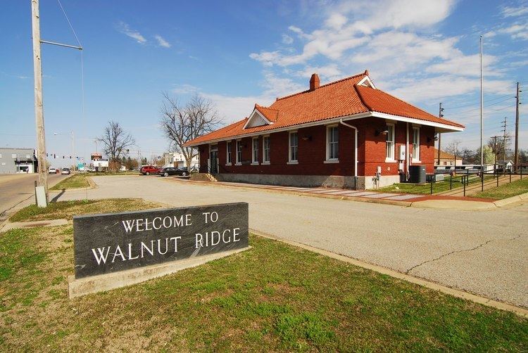
Walnut Ridge–Hoxie business route
U.S. Route 67 Business (US 67B, Hwy. 67B) is a 4.84-mile (7.79 km) business route of US 67 in Lawrence County, Arkansas. The route begins at US 63/US 67 in south Hoxie and runs north to terminate at US 67 in Walnut Ridge.
The highway begins at US 63/US 67 in south Hoxie and runs northeast to US 63B. The two routes have a brief overlap until US 63B splits east along the BNSF railroad tracks. US 67B continues northeast through downtown Hoxie as Texas Street, becoming Front Street upon entering Walnut Ridge. The route parallels the Amtrak line until the Walnut Ridge Amtrak station within the Walnut Ridge Commercial Historic District, both listings on the National Register of Historic Places. Shortly after passing the Amtrak station, US 67B has a junction with US 412 which also serves as the western terminus of Highway 34. US 412/US 67B overlap briefly west for 0.2 miles (0.32 km), passing the historic Old Walnut Ridge Post Office before US 67B turns north onto 4th Street. The route runs through a few blocks of residential properties before becoming a rural route. The route terminates at US 67 in north Walnut Ridge.
Mile markers reset at concurrencies. The entire route is in Lawrence County.
Biggers business route
U.S. Route 67 Business is a 0.65-mile (1.05 km) business route in Randolph County, Arkansas. Posted as US 67B, its southern terminus is at U.S. Highway 62 and U.S. Highway 67. The route runs north to Biggers/Reyno Road (a former alignment of U.S. Route 67) in downtown Biggers, where it terminates.
Datto business route
U.S. Highway 67 Business is a 0.23-mile (0.37 km) business route in Clay County, Arkansas. Posted as US 67B, it runs from US 67 west to 1st Street.
Historic route in Illinois
The former ALT US 67 is now Illinois Route 267