
Elevation 7,027 m Mountain range Spantik-Sosbun Mountains | Prominence 1,187 m Parent range Spantik-Sosbun Mountains | |
 | ||
Location Gilgit Baltistan, Pakistan Similar Diran, Rakaposhi, Batura Muztagh, Malubiting, Ultar | ||
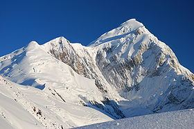
Spantik or Golden Peak is a mountain in Spantik-Sosbun Mountains subrange of Karakoram in Nagar Valley, Gilgit Baltistan, Pakistan. Its northwest face features an exceptionally hard climbing route known as the "Golden Pillar". It lies east of Diran and northeast of Malubiting.
Contents
Map of Spantik
Climbing
Spantik was first climbed in 1955 by Karl Kramer's German expedition. The most commonly climbed line follows the south east ridge, which was attempted by the Bullock Workman party in 1906. The ridge rises 2700 metres over a lateral distance of 7.6 km, at angles which are mostly less than 30 degrees, with a few sections up to 40 degrees. It contains varied terrain, from rocky outcrops to snow and ice and scree.
The mountain is very popular with organised commercial expeditions, due to its relative ease of ascent and scarcity of objective dangers. The short 3 day approach trek across straightforward terrain also provides for easy access and gradual acclimatization. This peak was scaled by Aus-Pak expedition in July 2011 led by a team of mountaineers from Army High Altitude School Rattu. Lt Col Abdul Aziz was supervising the team of Climbers.The peak can be approached from Nagar Valley as well as from Baltistan side. The First expedition was held in 1988, the team composed of six Pakistan Army Personnel with German Team, The first Pakistani who reached the summit was Captain (now Brigadier) Muhammad Moiz Uddin Uppal, Another expedition named the China-Pakistan Friendship Expedition scaled Spantik Peak. Expedition leader Lt Col (retired) Dr Abdul Jabbar Bhatti in a call from the summit said that the expedition members took turns to reach the summit between 1:45pm and 2:15pm on Sunday July 15. Earlier, the summit team, which had started from Camp II (5, 600 meters) on July 14, set up Camp III (6,000 metres) the same day and pushed for the summit the following day. C III was established 300 meters lower than planned, which, combined with worst weather conditions and lack of visibility during return from summit, resulted into missing the route and forced whole team to spend the night outside the camp, at time when members were already exhausted. Digging out snow caves was the only option for protection from extreme environment.