
Country Germany Vehicle registration B Area 8.03 km² Local time Wednesday 1:22 AM | State Berlin Time zone CET/CEST (UTC+1/+2) Website Official homepage Elevation 35 m | |
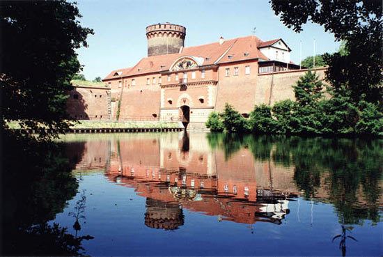 | ||
Weather 11°C, Wind W at 11 km/h, 58% Humidity Points of interest Spandau Citadel, Spree, Militärhistorisches Museum Flugplatz, Tiefwerder Wiesen, Fort Hahneberg | ||
Spandau ( [ˈʃpandaʊ̯]) is the fifth of the twelve boroughs (Bezirke) of Berlin. It is the fourth largest and westernmost borough, situated at the confluence of the Havel and Spree rivers and along the western bank of the Havel, but the least populated.
Contents
- Map of Spandau Berlin Germany
- Overview
- Demographics
- Subdivision
- Politics
- Buildings
- Notable people
- Twin towns
- References
Map of Spandau, Berlin, Germany
Overview
In the north it borders on the district of Oberhavel, in the west on the district of Havelland and the city of Potsdam in the federal state of Brandenburg. Modern industries include metal working, chemical and electrical factories. Since 1969, BMW manufactures motorcycles only in the motorcycle factory in Spandau. Spandau is famous for its Renaissance citadel. Spandau was the location of the Spandau arsenal until 1919 and the notorious Spandau Prison until the prison was demolished in 1987. The British New Romantic band Spandau Ballet took their name from the Spandau borough in the British sector of former West Berlin.
The borough headquarters occupy Spandau Town Hall, built in 1913.
Demographics
As of 2010, Spandau had a population of 223,962, of whom 62,000 (27%) had a migration background or were of non-German ethnicity.
Subdivision
Spandau Borough is divided into 9 quarters (Ortsteile):
Politics
At the 2016 elections for the parliament of the borough (Bezirksverordnetenversammlung) the following parties were elected:
Buildings
A Catholic church, St. Marien am Behnitz, designed by August Soller, was completed in 1848.