Harman Patil (Editor)

Southside (Richmond, Virginia)

Updated on
Edit
Like
Comment
Share on FacebookTweet on TwitterShare on LinkedInShare on Reddit
Southside (Richmond, Virginia)

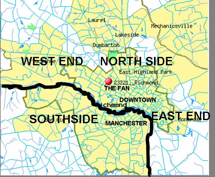
The Southside of Richmond is an area of the Metropolitan Statistical Area surrounding Richmond, Virginia. It generally includes all portions of the City of Richmond which lie south of the James River, and includes all of the former city of Manchester. In some contexts, the term "Southside of Richmond" may also include some northern areas of adjacent Chesterfield County, Virginia in the Richmond-Petersburg region.

Contents

Since there is no one municipal organization that represents this specific region, the boundaries are loosely defined as being south of the James River and west of Interstate 95 (formerly Richmond-Petersburg Turnpike) with a southern border extending approximately to Chester, Virginia. Some portions of the Southside of Richmond closest to the downtown area north of the river are also considered part of Downtown Richmond.

Unincorporated towns and neighborhoods

  • Adams Park
  • Beaufont
  • Bellemeade
  • Belmont Woods
  • Belt Center
  • Blackwell
  • British Camp Farms
  • Broad Rock
  • Brookbury
  • Brookhaven Farms
  • Cedarhurst
  • Cherry Gardens
  • Chippenham Forest
  • Cofer
  • Cottrell Farms
  • Cullenwood
  • Davee Gardens
  • Deerbourne
  • Elkhardt
  • Fawnbrook
  • Forest Hill
  • Forest Hill Park
  • Forest Hill Terrace
  • Forest View
  • Gravel Hill
  • Hickory Hill
  • Hillside Court
  • Hioaks
  • Huguenot
  • Jahnke
  • Jeff Davis
  • Old Town Manchester
  • Maury
  • McGuire
  • McGuire Manor
  • Meadowbrook
  • Midlothian
  • Murchies Mill
  • Northrop
  • Oak Grove
  • Oxford
  • Piney Knolls
  • Pocoshock
  • Powhite Park
  • Reedy Creek
  • Reservoir Heights
  • South Garden
  • Southampton
  • Southwood
  • Springhill
  • Stony Point
  • Stratford Hills
  • Swansboro
  • Swansboro West
  • Swanson
  • Walmsley
  • Warwick
  • Westlake Hills
  • Westover
  • Westover Hills
  • Westover Hills West
  • Willow Oaks
  • Windsor
  • Woodhaven
  • Woodland Heights
  • Worthington
  • Industrial and commercial sites

  • Defense Supply Center, Richmond (DSCR)
  • Philip Morris USA manufacturing center
  • Overnite Transportation (recently bought out by United Parcel Service)
  • Deepwater Terminal (Port of Richmond)
  • Chippenham Johnston Willis (CJW) Medical Center
  • Commercial districts

  • Stonebridge Shopping Center
  • Old Manchester
  • Hull Street
  • Midlothian Turnpike
  • Westover Hills
  • Stratford Hills
  • Stony Point Fashion Park
  • Cloverleaf Mall
  • The Arboretum
  • Bellwood flea market
  • Bermuda Square
  • Sycamore Square
  • Oxbridge Square
  • Chesterfield Meadows
  • Parks and recreation

  • James River Park
  • Forest Hill Park
  • Canoe Run Park
  • Powhite Park
  • Major streets and roads

  • Interstate 95 (formerly Richmond-Petersburg Turnpike)
  • Jefferson Davis Highway (U.S. Route 1 and U.S. Route 301)
  • Forest Hill Ave (short portion is (U.S. Route 60)
  • Semmes Avenue (U.S. Route 60)
  • Belt Boulevard (State Route 161)
  • Iron Bridge Road (State Route 10)
  • Broad Rock Road (State Route 10)
  • Huguenot Road (State Route 147)
  • Courthouse Road (State Route 653)
  • Hull Street (U.S. Route 360)
  • Midlothian Turnpike (U.S. Route 60)
  • Chippenham Parkway (State Route 150)
  • Pocahontas Parkway (State Route 895)
  • Powhite Parkway (State Route 76)
  • State Route 288
  • Bridges over James River

  • James River Bridge (Interstate 95)
  • Mayo Bridge (U.S. Route 360)
  • Manchester Bridge (U.S. Route 60)
  • Robert E. Lee Memorial Bridge (U.S. Route 1 and U.S. Route 301)
  • Boulevard Bridge (State Route 161)
  • Powhite Parkway James River Bridge (State Route 76)
  • Huguenot Memorial Bridge (State Route 147)
  • Edward E. Willey Bridge (State Route 150)
  • World War II Veterans Memorial Bridge (State Route 288)
  • References

    Southside (Richmond, Virginia) Wikipedia